
This story was first published in The Times-Picayune|NOLA.com and was republished with permission in the November issue of PRC’s Preservation in Print magazine. Interested in getting more preservation stories like this delivered to your door nine times a year? Become a member of the PRC for a subscription!
America transformed around the turn of the 20th century. The agrarian days before the Civil War had become a distant memory, supplanted by rapid industrialization, railroad-building and dazzling technological breakthroughs. Income and education levels rose, expanding the ranks of the middle class. More Americans took time and money to explore their vast country, as well as engage its challenges. And there were plenty: high rates of immigration and urbanization had brought to light the problems of the city, while wanton exploitation of natural resources did the same for wild areas.
A spirit of citizen-led intervention arose, and politicians followed. What resulted was a remarkable set of reforms and infrastructure advancements from which emerged the modern nation. Historians call it the Progressive Era, and it helped launch the American century.
New Orleans was no exception. In terms of livability, the city ended the 19th century muddy, uncomfortable and unhealthy, and came into the 20th century dramatically modernized. Drainage systems, water and sewerage treatment plants, street paving and park landscaping, telephones, incandescent lighting and electrified streetcar networks, automobiles, steel-frame construction, urban planning and zoning — even playgrounds — all came to fruition from the 1890s to the 1920s. Yellow fever and cholera epidemics became bad memories, death rates dropped, and life expectancies rose.
One of the lesser-known but most emblematic Progressive Era improvements stares you in the face when you come home each evening. It’s the number on your door.
Advertisement

The seemingly trivial task of enumerating houses took nearly two centuries for New Orleans to perfect — and that’s faster than many cities. Like zoning ordinances and preservation statutes, logical and consistent house-numbering systems come about only when a certain level of civic agency passes to the hands of authorized professionals charged with oversight of the entire city.
House addresses became problematic because New Orleans’ colonial founders did not establish a logical framework when they first laid out the city plat. Thus, unlike places like Salt Lake City, they missed the opportunity to create a regularized system from the start.
Not until the early American years did an organized enumeration attempt materialize. To design it, authorities tasked a man named Matthew Flannery, probably because he had also been contracted to conduct the 1805 door-to-door population census.
Unfortunately, Flannery, an American newcomer to the Creole city, brought some ill-fitting outsider’s assumptions to the task. He imposed neat orderly cardinal directions upon the curvaceous city, which wore them like a cheap suit. He anointed Orleans Street as the principal axis, which made sense only on paper — and not even then, once Canal Street became the chief artery in the 1810s. He also decided to enumerate existing houses sequentially in disregard of vacant lots and future changes in density — then overcompensated by arbitrarily doubling all the numbers.
What resulted was a herky-jerky jumble that became even less popular when homeowners were mandated to pay Flannery two and a half bits for a tin house-number plaque. People rejected Flannery’s over-engineered mess and replaced it with imprecise but reliable descriptions, such as “Dauphine corner Orleans,” “St. Peter at the Square” or “at the Exchange on Chartres.”
Advertisement

The city intervened in 1831, requiring every 20 feet of street space to be enumerated regardless of structural development, with odd and even numbers placed consistently on either side of the street. No other system-wide rule was stipulated, although the ordinance did specify how houses should post their signage. Finding an address in circa-1840s New Orleans would have entailed seeking an oval-shaped tin or iron plate above each door, on which the number was supposed to be painted at least three inches high in black oil and varnished to protect it from the elements. Street signs had black lettering on a yellow field if the street ran perpendicular to the river, and white lettering on a black field for parallel. The system was never fully adopted, nor documented, frustrating researchers to this day.
The year 1852 brought major changes to the administration of New Orleans, including the adoption of modern municipal districts and wards. The reshuffling also provided an opportunity to rework once again the house-numbering system. Mostly this effort took the form of fixing quirks and smoothing over anomalies rather that a wholesale redesign.
While the new system did maintain odd-and-even street siding and increased the numbers with distance from Canal Street or the river, it neglected to distribute the numbers consistently and paid no heed to the significance of a block. Irregularities were small and tolerable on inner-city blocks, but exacerbated in the outer neighborhoods.
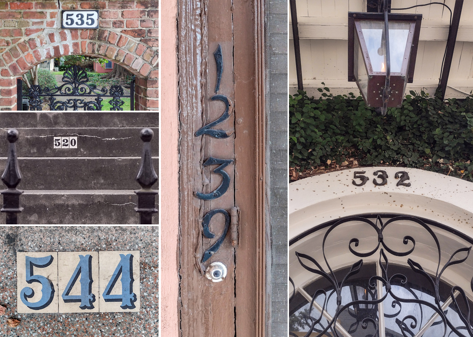
Photos by Richard Campanella
Buildings on today’s 3100 block of Magazine Street, for example, were labeled in the 800s, whereas a parallel block on Constance numbered in the 500s, and nearby Tchoupitoulas counted five solid blocks all in the 900s. Mail carriers delivering letters to homes, which the U.S. Postal Service started during the Civil War in some northern cities, would have endured this erratic system when home delivery reached New Orleans in the late 1800s.
Mail delivery plus the emerging progressive sensibilities of the 1890s demanded that the house-numbering problem be fixed fundamentally. Following an 1893 ordinance, City Engineer L.W. Brown, the same man in charge of the infrastructure improvements, took the lead. His staff kept what worked about the two prior systems — the Canal Street/Mississippi River axes and odd/even siding — and wiped away everything else.
The new design, developed in 1893 and deployed in 1894, utilized the Philadelphia-inspired “decimal system,” which consistently incremented by 100 per block, such that location and distance could be pinpointed just by looking at an address. “One does not have to hunt for a number,” beamed a supportive Picayune editorialist. The system also followed Philadelphia’s protocols for parcels and blocks of varying sizes, multiple-unit buildings and similar anomalies.
Advertisement

Other American cities followed suit, in the spirit of municipal improvement as well as national standardization. It’s no coincidence that the house-numbering reforms occurred at the same time the Mendenhall Order of 1893 formally converted the U.S. Coast and Geodetic Survey to the metric system. The decimal system of house numbering is essentially the metric system of measurements inscribed into the cityscape.
One of the biggest stakeholders in the conversion project in New Orleans was the publisher of the City Directory, L. Soards, who strongly advocated for the reform. “In the past there [have] been many proposals…that came to naught,” he wrote to readers of the Picayune newspaper in 1893. “I can truthfully say that the present proposed ordinance is the most sensible, practicable, the simplest and best of any yet framed.”
His business dependent on it, Soards nervously tracked the progress of the conversion in 1894, at one point admonishing readers of the Daily Item newspaper, “Caution[:] former or old numbers…should and must be retained till the New City Directory comes out, otherwise serious inconvenience would arise!”
“Will you ask your readers not to remove the old numbers from their houses?” pleaded one letter writer to the Picayune during the transitional period. “Mail is still sent to them[!]”
Normally such civic change brings with it resistance — and there was some. Citizens successfully fought the requirement to purchase official metal plates on concerns about monopoly, a hot issue in the Progressive Era. But the system itself, which represented so vast an improvement, won swift and widespread acceptance from residents and particularly merchants.
Advertisement

While the decimal system succeeded in the streets of New Orleans, the Mendenhall Order fell flat in converting the nation to the metric system, an effort on which the U.S. government would eventually give up many years later. Other cities also fell short of New Orleans’ success. Parts of lower Manhattan and Paris, for example, never adopted the decimal system, and seeking an address there today can entail canvassing numerous blocks, lest one invokes a smartphone. Some European cities got stuck between the two systems Soards worried about and post both the old and new numbers on houses to this day. Cities in less-developed countries commonly endure the sort of ad-hoc systems New Orleans had in the early 1800s.
The decimal-based “Philadelphia system” remains the system we use today. Testimony to its apt design, it was successfully extended into 20th-century subdivisions, and inspired similar arrangements in adjacent suburbs, which had learned from New Orleans’ mistakes.
The 1894 system represented a rational solution to an old problem, and attests to the Crescent City’s progressive spirit in matters of municipal improvement at the dawn of the American century.
Richard Campanella is a geographer with the Tulane School of Architecture and author of The West Bank of Greater New Orleans; Cityscapes of New Orleans; Bourbon Street: A History; and other books. Campanella may be reached through richcampanella.com, rcampane@tulane.edu, or@nolacampanella on Twitter.
Advertisements