


One day in 1922, a U.S. Army Air Service biplane based out of Montgomery, Ala., wafted through the midsummer skies over New Orleans, as its passenger pointed a camera down from the open cockpit and snapped the shutter.
These were not the first aerial photographs captured of the Crescent City; both oblique and nadir-view scenes had been taken as early as 1914. But these large-format frames were among the highest in quality to date, depicting dazzling details of the streetscape at a time just prior to massive urban transformations. Featured below (at left) is one particularly informative frame, showing the Faubourg Tremé in a state that would have been readily recognizable to denizens as far back as the mid-1800s. It was taken on July 10, 1922, over the Fifth and Sixth wards looking toward the river, with the heart of Tremé in the foreground and the rear of the French Quarter in the back.
In this column, I’ll highlight key features labeled by number on the photograph. (Click on the images below to enlarge them and see the highlighted numbers.) A key feature in the scene is the famous Old Basin Canal (1), seen here in decrepit condition 128 years after it was first dug by slaves and convicts under the direction of Spanish Gov. Hector de Carondelet. Initially envisioned as a drainage outfall, the “Carondelet Canal” opened in 1796 and succeeded in speeding the flow of urban runoff to Bayou St. John and out into Lake Pontchartrain. Later privatized, the channel was expanded for navigation and reopened in 1817, whereupon a steady stream of schooners and barges unloaded everything from lumber, firewood, lime, clay, pitch and tar, to finfish, shellfish, fur and game, at the turning basin (2) for which Basin Street was named.

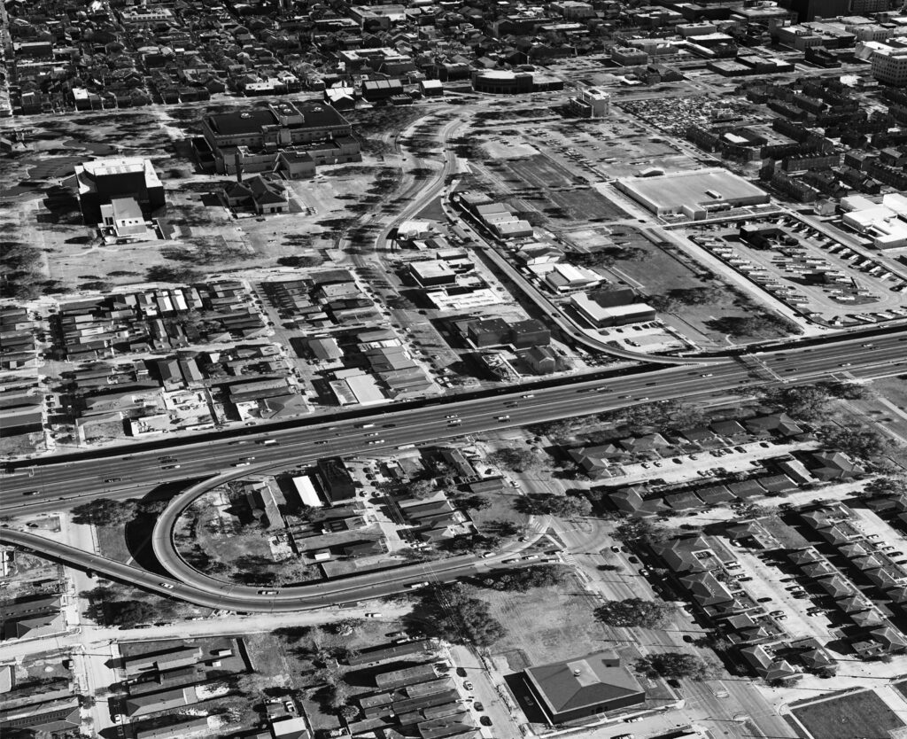
When the Pontchartrain Railroad began service on Elysian Fields Avenue in 1831, and when the larger “New” Basin Canal opened uptown in 1836, the Carondelet Canal came to be viewed as “old” — hence its enduring nickname, the Old Basin Canal. Despite the competition for lake trade, the malodorous channel remained useful into the 20th century, imparting the Tremé area with an economy of light industry, food processing, and storage warehouses (4), while enabling railroad tracks (3) of the Frisco System/New Orleans Terminal Company to share its right-of-way into downtown.
By the 1920s, the Old Basin Canal, now under the control of the Southern Railway, had lost most of its cargo business to vehicular traffic, while neighbors came to view the hyacinth-clogged ditch as a nuisance and traffic obstacle. In 1924, the city purchased the corridor with the intention of “removing the menace to health of the Old Basin canal,” according to the New Orleans Item, “and converting it into a parkway or a sunken garden.” Filling began in 1925, followed by landscaping in the 1930s. Yet most of the two-mile-long swath remained a weedy interstice until 2006, when citizens began advocating for its conversion into a linear park — today’s Lafitte Greenway, which opened in 2014.
Passengers taking the Southern line into the Beaux Arts-style rail station on Basin at Canal Street (designed by Daniel Burnham and built in 1908 just out of view to the upper right) got quite an introduction to New Orleans. With its office visible at (5), now the Basin Street Station welcome center, the Southern rolled by the legal red-light district known as Storyville (1898 to 1917), a portion of which is visible at (6), the circa-1789 St. Louis Cemetery No. 1 at (7), the circa-1826 Old Mortuary Chapel (St. Anthony’s Church, now Our Lady of Guadalupe), at (8), and the gaudy “sporting houses” (bordellos) along Basin Street.
At (9) we see a rare glimpse of the North Rampart location of the Byzantine-style Shangarai Chasset (Gates of Mercy) Synagogue, whose congregation by this time had moved uptown. A block away at (10) are the trio of matching townhouses designed by James Gallier Sr. and James Dakin in 1834 and opened the next year. Known endearingly as the “Three Sisters of Rampart Street,” the stately temple-like mansions imparted an upscale aura to an area that elsewhere could be rather raffish. Sadly, each “sister” fell to the wrecking ball between 1930 and 1950, and the site today is a parking lot.
Where Orleans Street crosses North Rampart, in alignment with St. Louis Cathedral at Jackson Square, we see a park that the city had officially named Beauregard Square (11), but everyone else called Congo Square. Here was one of the few places where, from colonial times up to the Civil War, enslaved Africans and their descendants could rendezvous on Sunday off-days, an opportunity many took to make music and perform dances in styles brought directly from West Africa. A few years after this photo was taken, the blocks behind Congo Square (12) were expropriated and razed for the construction of the Municipal Auditorium, completed in 1929 for events that had previously taken place in the Old French Opera House on Bourbon Street, until its fiery demise in 1919. The sewerage pumping station with the smokestack visible at (13) had previously been the location of the ominous Orleans Parish Prison, site of the lynching of 11 Sicilians in 1891.
Forty years later came another major expropriation of Tremé. The targeted area entailed the blocks adjacent to Congo Square and the Municipal Auditorium, and the goal was their transformation into a cultural center that would eventually comprise the Mahalia Jackson Theater for the Performing Arts (1973) and Louis Armstrong Park (dedicated 1980). Among the many historic buildings razed for this years-long urban renewal project was McDonogh School No. 18, built in 1907 and visible at (14).
Just about all the residents of the community visible here obtained some or most of their sustenance from the magnificent Tremé Market (15). This open-stall food emporium, built in the 1830s and by now one of the largest of the city’s 34 municipal markets, extended 350 feet along the neutral ground of Orleans Avenue as it emerged from Congo Square. Like many other neighborhood markets, it was marked by a picturesque cupola, below which traffic on Villere Street could pass directly through the marketplace. The Tremé Market was demolished in the 1930s and replaced by an Art Deco market structure that later became a grocery store and is now the main office for the nearby apartments known as the Residences at Tremé Market. Though originally on Orleans Avenue, the sites of both the 1830s and the 1930s market structures now occupy Basin Street, thanks to the mid-1950s reengineering project that merged these two arteries into a single curvaceous connection, one that was later joined by a down-ramp of Interstate 10.
All along North Claiborne Avenue at (16) we see the famous Claiborne oaks, planted along this extra-wide neutral ground as early as the 1850s, and ultimately extending from Tulane Avenue to Elysian Fields Avenue. Forming nearly two miles of shady foliage, the trees were uprooted in 1966 and either replanted or destroyed, in preparation for the Interstate 10 Claiborne Overpass, completed four years later. Note the draw bridge at (17), where traffic had to squeeze down to a narrow pathway to cross the Old Basin Canal — one of the many reasons for which residents called for the aged channel to be filled. And yet for every sign that modernization was about to transform Tremé, there also appeared evidence of cultural continuity — such as the French Benevolent Association Hospital (18), which served the deep-rooted Francophone Creole community of this area. The site is now the home of the Knights of Peter Claver & Ladies Auxiliary, the African American Catholic fraternal organization that remains an important religious and civic body in the Faubourg Tremé.
We conclude with the blocks in and around (19) and (20), which, in the late 1930s, were expropriated and demolished for the construction of the Lafitte Housing Projects, one of the city’s six original federally funded public housing complexes. The effort replaced a mostly black neighborhood of owners and renters of historic cottages and shotgun houses, with modern garden apartments that were rented at subsidized rates to exclusively black families. Working-class white families rented units at the white-only Iberville Projects, built at the same time and in the same style in the neighborhood that had previously been Storyville.