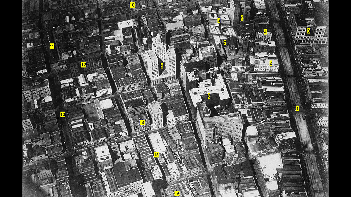


Inspect a satellite image of greater New Orleans and you will readily see that the landscape of Nine Mile Point, across the Mississippi from Carrollton, contrasts with the surrounding conurbation. So named for its riverine mileage from the French Quarter, this promontory retains substantial tracts of forest, pasture, and until recently, croplands, set within the metropolis’s last readily identifiable French long-lots. Yet Nine Mile Point is also home to heavy industry, electrical production, grain storage, and warehousing—as well as residential areas varying from suburban to sub-rural. Nine Mile Point is additionally a transportation hub, with highways swirling on and off the Huey P. Long Bridge, vessels moored along the riverbank, shipyards in Avondale, and extensive rail yards on both flanks.
Over the centuries, these varied land uses, and the forces behind them, have evolved, interacted, and sometimes clashed. No one feature better tells that story than Seven Oaks, the grand plantation mansion that lorded over Nine Mile Point from the antebellum age to the space age.
Once the domain of the Houma, Washa, Chawasha, and Chitimacha bands, this land came into the colonial fold in 1719 under the name Petit Desert (Little Wilderness). It comprised part of a sprawling concession granted by the Company of the West to three French officials, who used one section as a transshipment depot to develop the other two sections. In 1720, settlers from Lorient, France arrived under Captain Ignace François Broutin to turn the wilderness into croplands, a grueling task that would soon fall to recently arrived West African slaves. Over the next two generations, various portions of Petit Desert would pass in and out of the ownership of Claude Joseph Villars Dubreuil, Francisco Bouligny, and Jean Louis Trudeau, among others. After 1785, it became the property of the intermarried families of Harang and Zeringue.
One of their scions, Camille Zeringue, born around 1790, took charge of the plantation upon reaching the age of majority, and by 1812 oversaw 34 arpents (1.2 miles) along what is now the Westwego riverfront. Raising primarily sugar cane, Zeringue developed the operation into one of the largest in the region, and because of its location, it offered opportunities to diversify his income streams. Toward that end, in 1830, Zeringue sold a sliver of land at the base of the promontory extending back to the Bayou Segnette swamps. The buyer was the Barataria & Lafourche Canal Company, in which he himself was an investor, and their mutual goal was to connect the Mississippi River with lakes Cataouatche and Salvador to reach the Barataria Basin to the south and Bayou Lafourche to the west. Such access would make Petit Desert a crossroads for trade between greater New Orleans and the resource-rich Barataria and Terrebonne basins. Using the labor of state-owned slaves, work on the channel began in 1830, reached the lakes in 1834, and seven years later, adjoined Bayou Lafourche with a lock, giving rise to the community of Lockport. Coupled with his sugar cane yields and sundry side products, the “Company Canal” helped make Zeringue a baron in the region.
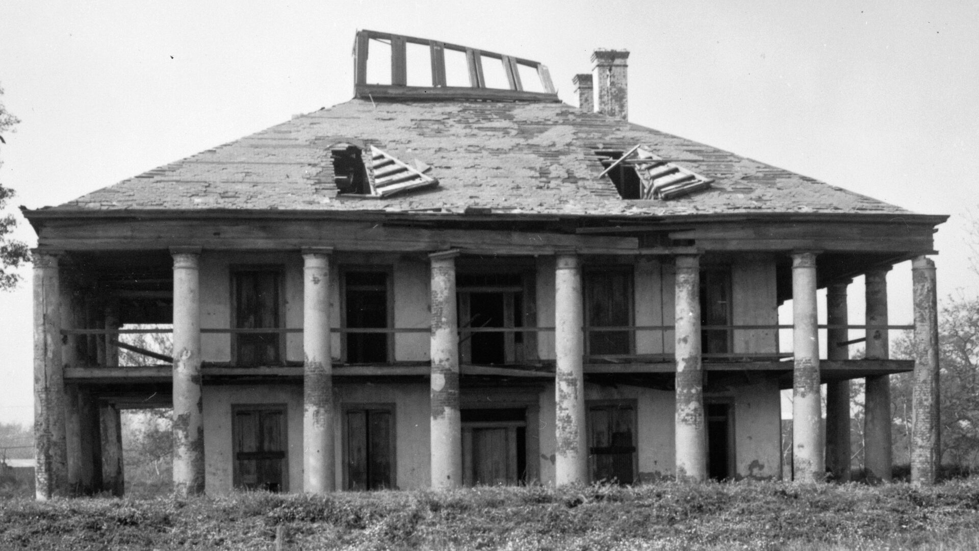
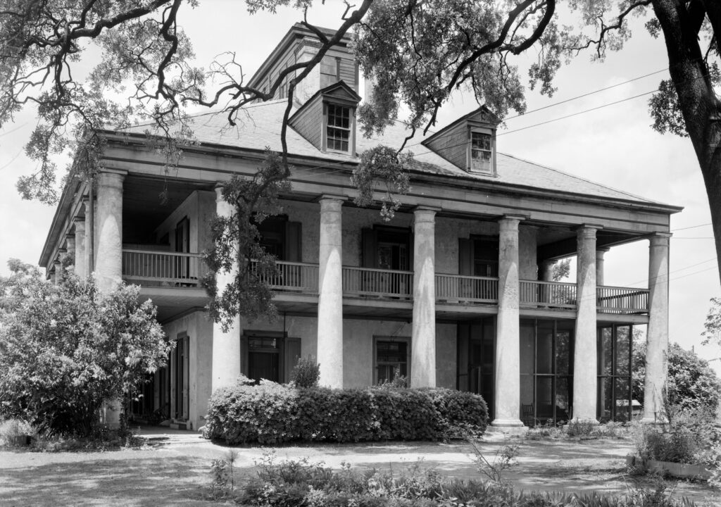
All that was missing from his grand manor was a residence to match, and in the late 1830s, Zeringue had just such an edifice constructed. According to architectural historian Samuel Wilson Jr., the mansion was “an excellent example of the style of Greek Revival as adapted to the Louisiana plantation house[:] large and almost square in plan, [with] twenty-six massive brick columns of the Doric order [and] a huge pyramidal slate roof,” topped with four symmetrical chimneys and a “belvedere [with] a magnificent view of the city and the river.” Zeringue named it Seven Oaks, either for the surrounding trees or its seven-columned galleries. Oddly, neither its architect nor its completion date is known with certainty, though historian Marc R. Matrana, in his book Lost Plantation, makes the case that the German-born New Orleans architect Valentine von Werner mostly likely designed the structure. Completed around 1840, Seven Oaks reflected the opulence of Louisiana’s sugar aristocracy, just as the plantation’s hundred-strong slave force, lodged behind the big house, explained its provenance. It was a golden age for the barons, time on the cross for the slaves, and in retrospect, it wouldn’t last long.
For Zeringue, change would come first in 1852, when the New Orleans, Opelousas, & Great Western Railroad pressed to expropriate a right-of-way across his plantation, which a court ruling forced Zeringue to allow. The tracks were laid through in 1853, and by year’s end, trains were puffing across Zeringue’s land, making money for others at his expense. Worse yet, in accessing Bayou Lafourche more swiftly, the rail service outcompeted shipping on Zeringue’s partly owned Company Canal.
Nine years later, when the Civil War broke out, the tracks became a potential ingress for Union troops. Confederate troops built earthen fortifications along the canal, and his plantation became their encampment, costing Zeringue more productive space just as the Union blockade quashed his exports. Federal occupation in May 1862 and incremental emancipation over the next three years would upheave the plantation economy, to say the least. Yet despite that Zeringue was an enthusiastic secessionist, Seven Oaks evaded destruction, and the family managed to endure the war’s aftermath.
His new enemy was the railroads, which, empowered with the legal right to expropriate, coveted Zeringue’s strategically positioned land—“183 acres…between the master house and the Company Canal,” according to Matrana—for a major rail terminal. The aging patriarch rejected a purchase offer from the Texas & Pacific Railroad, so in 1870 the company sued to seize the land. T&P’s court victory, wrote Matrana, himself a family descendent, “demonstrates the greatly declining social, political, and economic status of…plantation owners” vis-à-vis the “political dominance of the railroads in the postwar South.” Attesting to this power shift is the fact that we know this area today not as “Petit Desert,” “Seven Oaks,” or “Zeringueville,” but by the catchy circa-1871 company name for its terminal, “We-West-Go,” designed to advertise its rail access to the western frontier. Thus, today’s Westwego.
After Camille Zeringue died in 1872, his heirs found their fields crisscrossed by track beds, their labor force difficult to secure, and their huge house in constant need of maintenance. The plantation went into decline, financially and otherwise. But in the process, it presented an opportunity to an unexpected duo from far away. In March 1892, a 65-year-old Spaniard by the name of Pablo Sala learned of the house and property and saw a potential that locals did not. Sala acquired the complex from Camille’s son Jean Fortune Zeringue, who had lost ownership in a stock-mortgage foreclosure to Citizen’s Bank. The transaction entailed Seven Oaks along with adjacent lands, including a strip along the Company Canal. Understanding the value of this waterway’s junction with the railroads and the river, Sala’s sister in Spain, Maria Sala y Fabregas—apparently sight unseen—coordinated with local surveyors to lay out the subdivision of Salaville. By 1893, up to 200 people lived in Salaville, most of them descendants of Zeringue’s slaves, and many of whom were congregants of the True Vine Baptist Church, which still operates today on historic Sala Avenue in downtown Westwego.
As for Seven Oaks, the elderly entrepreneur had something innovative in mind. In what may be the region’s first major adaptive reuse of a plantation house for tourism, Sala made Seven Oaks into a weekend getaway for city dwellers across the river. Named Columbia Gardens, the attraction opened to huge crowds in 1893, offering music, entertainment, food and drink, ornamental gardens, baseball games, hunting and fishing, and the novelty of electrical illumination, plus riverside breezes from the mansion’s scenic gallery. “The resort was indeed ahead of its time,” wrote Matrana. “Such multifaceted attractions did not routinely develop until much later, and the use of the mansion as a tourist attraction was very unusual prior to the turn of the century.” Unfortunately, Sala died in 1894, and Columbia Gardens lost its visionary. In ensuing years, Seven Oaks changed hands repeatedly, as railroad interests gained control over more of the adjacent land.
In 1912, the Missouri Pacific Railroad Company bought the old house, and over the next two decades, the former Zeringue Plantation became a veritable train yard strewn with storage tanks and fronted by the cacophonous transfer (train) ferry terminal to Walnut Street. Amid it all stood Seven Oaks, increasingly forlorn yet still imposing, its eighteen rooms rented out to tenants. One woman who lived there as a child remembered hearing the roar of lions at Audubon Zoo, less than a mile across the river. After the last occupants departed in 1954, the mansion fell into disrepair exacerbated by vagrants, looters, and Hurricane Betsy’s winds in 1965. Suburban Westwego had grown to its south and Bridge City to its west, while oil tanks arose practically in its shadows.
By the 1970s, Seven Oaks’ belvedere had collapsed into the attic, and dormers became gaping holes in the roof. Eaves and galleries had broken free of wisteria-entwined columns, looking like a Mayan ruin. Preservationists with the Louisiana Landmarks Society and other organizations pleaded with the Texas Pacific-Missouri Pacific Railroad Company to stabilize what remained and make into a heritage park. But state and local authorities offered only tepid support, and railroad officials remained silent.
In 1977, they finally responded. According to Mary Cable, writing wistfully in her 1980 book Lost New Orleans, “First, they made some sanctimonious public pronouncements: the house, unfortunately, was a wreck [and] a hazard to company employees, and the Westwego city government had condemned it. … People ought to put their effort and money into something else.” Shortly thereafter, on August 27, 1977, “the bulldozers arrived and sent Seven Oaks into eternity.”
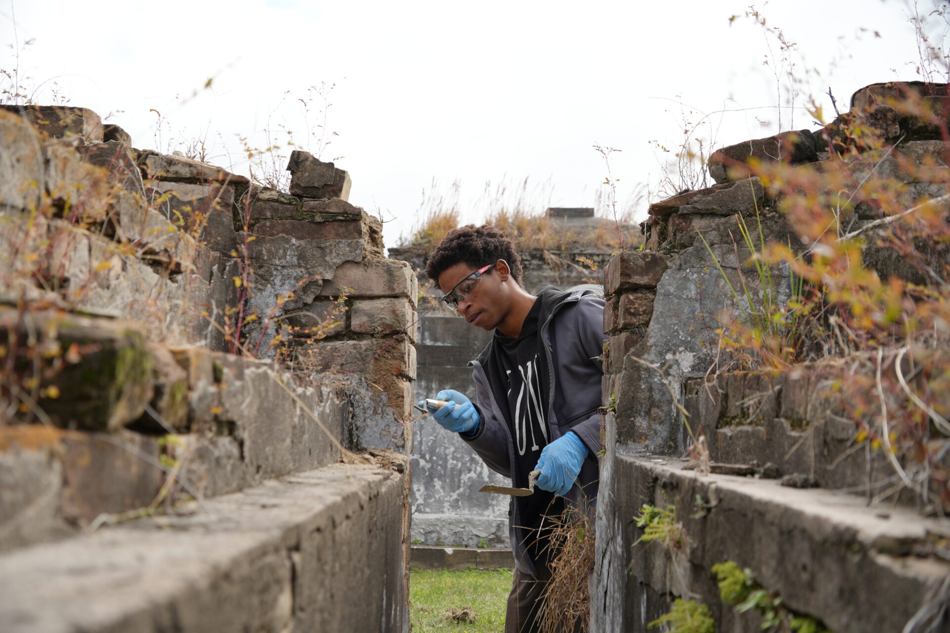
A visit to the site today brings one to a plaque and granite monument to the lost landmark. It also places a visitor amid the various Nine Mile Point landscapes in which Seven Oaks had played a role. Just to the south are the concrete walls of the Company Canal lock, behind which one can still see the slight depression dug by slaves of the now-filled channel paralleling Louisiana Street. Just to the east are the railroad tracks and moored barges that made the area into a transit hub. Just to the north are those 34 frontage arpents comprising the Zeringue plantation at its peak. And just to the west are fields still tracing the elongated shapes of old French long-lots, starting with that original 1719 concession of Petit Desert.
Streetscapes is written by Richard Campanella, a geographer with the Tulane School of Architecture and Built Environment and author of “Draining New Orleans,” “Bienville’s Dilemma,” and other books. This material was drawn from his 2020 publication with LSU Press, “The West Bank of Greater New Orleans—A Historical Geography.” Campanella may be reached through richcampanella.com, [email protected], or @nolacampanella on X.