This story appeared in the September issue of PRC’s Preservation in Print magazine. Interested in getting more preservation stories like this delivered to your door nine times a year? Become a member of the PRC for a subscription!
A recent social media conversation debated why a seemingly well-positioned restaurant in the heart of Uptown New Orleans had seen a litany of failed establishments and struggles to attract a new occupant. Is it just one of those hard-luck locations, where lingering memories of prior disappointments taint the incoming occupant?
It certainly wasn’t on account of excess supply and insufficient demand, as this is the only zoned eatery for blocks around in an affluent residential neighborhood replete with what one might call “the foodie demographic.” A decent diner here ought to have a lock on the market; just look at the success of other restaurants isolated in comparable residential neighborhoods, such as Vincent’s, Clancy’s and Pascale Manale’s — not to mention Mosca’s in Waggaman and Middendorf’s in Manchac, which are far more isolated on the outskirts of town.
Let’s set aside those examples for now, and focus instead on where most restaurants operate, including successful ones. They are usually in commercial districts — that is, clusters surrounded by other enterprises, including, paradoxically, their own competition.
Advertisement

In geography, this phenomenon is called agglomeration — the tendency of firms in free-market economies to settle adjacently with rivals. It’s what George W. Engelhardt described as “concerns akin assembl[ing] together,” as he cast his eyes across downtown New Orleans in 1904 and noticed how “the produce and fruit trade…has a street or two of its own; lumber…takes to the basins” of the old barge canals; “the grocery and provision lines, the import coffee trade, the iron works, the printing and publishing houses, the horse and mule markets have each their own special locality.”
Turn-of-the-century New Orleans also had a theater district, a cotton district, a “Wall Street” (financial district), a cotton-pressing district (two, in fact), a sugar and rice district and, of course, red-light districts. It also had particular streets specializing in high-end retail emporia (Canal), shoes and other soft goods (Magazine) and wholesaling (Poydras).
Why? In the case of manufacturers and value-added firms, such as cotton pressors (in today’s Lower Garden District and Bywater), or sugar processors (on the French Quarter riverfront), agglomerating brought down production costs by capitalizing on transportation facilities, labor sources, supply chains, energy, water or other key inputs.
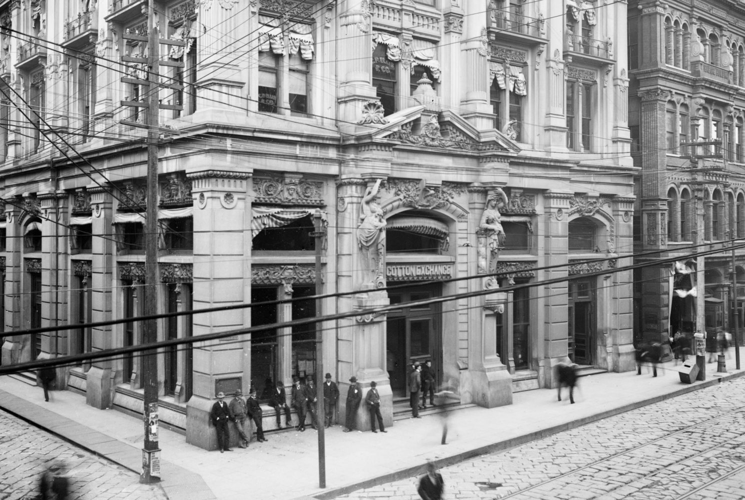
In this photo from circa 1900, conversations among traders, like these folks on break outside the New Orleans Cotton Exchange in the heart of the “cotton district,” help explain why industry agglomerations form. Photo courtesy of the Library of Congress.
In the cases of professional agglomerations like those of the cotton and financial district on Carondelet and Gravier, or Newspaper Row on Camp Street, clustering enabled industry players to form professional alliances, make deals, share leads and stay informed.
Those enterprises dealing with walk-in customers, such as retailers, eating and drinking establishments and entertainment, are perhaps the most interesting agglomerators, since it would seem they’d have the most to lose by saddling up to their competition.
But, in fact, savvy business owners realize the agglomeration itself exerts a greater gravitation pull of potential customers than any one storefront, and that the augmented foot traffic can benefit all constituent members.
Want to see a play or moving picture? Well, you may not know which, but you do know that most theaters are clustered on Canal Street in and around the Rampart and Basin intersections — “the theater district,” circa 1900s. So you head over there, and readily find something you want to see. What drew you? The agglomeration. And while you’re there, before or after the show, you may want to grab a refreshment, making the theater district also something of a nighttime entertainment district, with its own agglomerating forces.
That’s why places like Bourbon Street formed (and once had its own cluster of theaters). Visitors today beeline for the rambunctious strip precisely because it’s a rambunctious strip, not because they’re specifically seeking one particular bar or dance club. Any given venue on Bourbon benefits from the fact that its competition has set up shop adjacently, creating a customer magnet with, quite truly, a worldwide catchment area.
Advertisement

Now consider the outlier — the lone theater or the isolated dance club. They may survive and even prosper, but only if they make it past that initial customer-generation threshold in which they’re able to draw customers from afar. Such entities are usually very good, iconic or famous (thus, Clancy’s et al), or very convenient or necessary, or some combination of the above (think Langenstein’s).
Economic theorist Harold Hotelling (1895-1973) articulated a related driver for agglomerating in Hotelling’s Model of Spatial Competition. Consider a two-mile-long island park in which only two vendors with pushcarts may sell food to visitors. Upon sizing up the situation, the two competitors might decide to split the park into one-mile-sized sections and position themselves in the middle of each, thus minimizing customers’ walking distance and assuring themselves decent sales.
But soon, as they scheme to maximize their profits, each vendor would realize that by moving closer to the middle of the entire park, he’d poach more of his rival’s customers, while still retaining his own (though some would have to walk further for food — a reminder that agglomeration is not always in the customer’s best interest).
The rival would act similarly, and edge ever closer to the same midpoint. In time, both pushcarts would be colocated, each eager to outcompete the other for the entire park’s visitors. One might lower prices or increase selections — a reminder that agglomeration can ultimately benefit the customer.
Think about this next time you end up traveling 20 blocks to get a subscription filled at a Walgreen’s — only to despair at the sight of a CVS right across the street.
Hotelling’s Model also explains why gas stations cluster at interstate exits, why auto vendors form “dealers’ row” along suburban service roads, and why mall designers invented the “food court”— an innovation that also had other agglomeration advantages, such as centralizing specialized services (like sanitation) and equipment (like gas and water lines for kitchens).
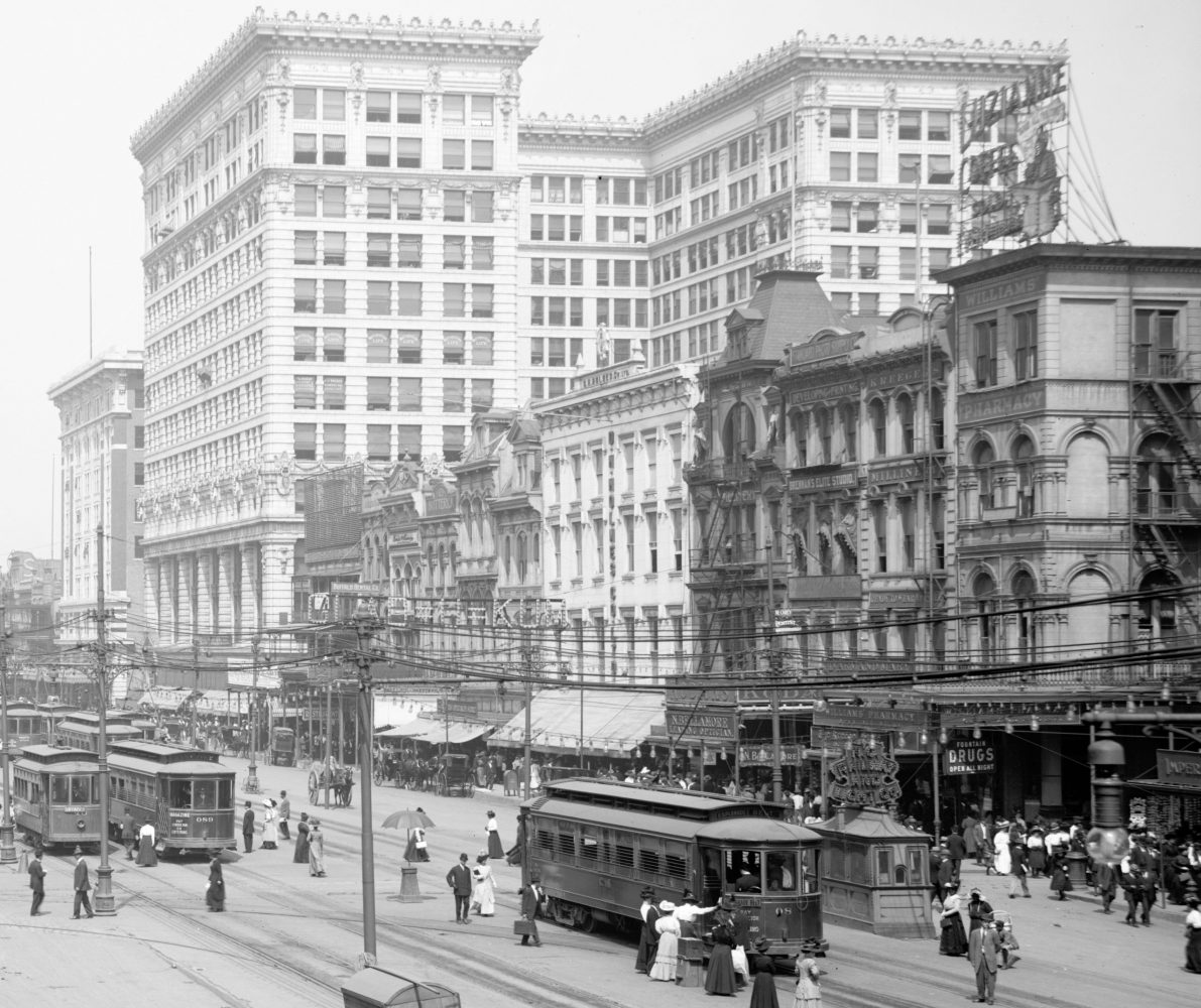
In the early 20th century, most high-end department stores were located on or near this section of Canal Street, including D.H. Holmes and Maison Blanche. Despite the fact that they were competitors, the stores’ proximity actually abetted their profitability. Photo courtesy of the Library of Congress.
To be sure, modern zoning has truncated site-selection considerations by preemptively designating spaces for certain concerns and environs. But most commercial zones originally formed as spontaneous agglomerations, and the economic drivers that created them are still very much at play today.
Which brings us back to that hard-luck restaurant on St. Charles Avenue. It may have a lock on the locals, but they weren’t enough to keep the business going, and apparently the food wasn’t good enough to overcome that spatial threshold. The enterprises never became famous or iconic, so few people living further away ever targeted them (“Hey, let’s drive uptown; I’m really in the mood for…”). Nor did those short-lived eateries benefit from passersby who need to go to the bank, the pharmacy or the grocery store, and decide to get a convenient bite to eat en route. No, they only were able to attract immediate neighbors or meandering college students, and failed to win them over, much less those further away. (Where do those students go now? To the agglomerations on Maple Street, in the Riverbend or on Freret Street!)
Advertisement

Agglomeration is relevant to preservation because the notion of a critical spatial mass pertains to its mission just as it applies to economic geography. In the early days of the movement, preservationists sought to save individual houses with singular historical narratives — the home of a famous person or the site of an important event. But as the movement gained traction and grew more sophisticated, it aimed to preserve the historical and architectural tout ensemble — that is, agglomerations of numerous structures with valued commonalities.
When we speak of the importance of historic districts in cities and towns today, we are essentially making an agglomerationist argument, recognizing that spatially cohesive aggregate preservation has the greatest impact in making cities livable, interesting and valuable. The effort to preserve the French Quarter in the 1920s and 1930s ranks among the best and most successful examples of this shift of emphasis from isolated to aggregate preservation, and the multiplier effect of benefits that it yields.
And at the heart of most of those historic districts is usually a cluster of businesses which had originally colocated for the same fundamental advantage: the benefit of the collective.
Richard Campanella is a geographer with the Tulane School of Architecture and author of The West Bank of Greater New Orleans; Cityscapes of New Orleans; Bourbon Street: A History; and other books. Campanella may be reached through richcampanella.com, [email protected], or@nolacampanella on Twitter.
Advertisement