

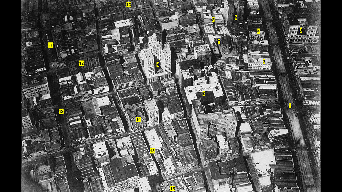
One morning in 1922, photographer Charles L. Franck climbed into the rear cockpit of a biplane and had the pilot take him on an exhilarating spin around downtown New Orleans. From an altitude of perhaps 1,500 feet, Franck captured a series of oblique shots constituting the best early aerial coverage of the city’s urban core. One particularly dazzling photo shows the heart of the Central Business District from a point above Tchoupitoulas Street looking down at an angle of 75 degrees, with Poydras to the left, Canal to the right, and the dense commercial cityscape glowing in the light of a rising sun. Roughly one-third of the visible building stock is antebellum in vintage, mostly two- and three-story storehouses and townhouses typical of the 1830s through 1850s; another third entails the larger and more ornate commercial buildings of the late 1800s; and the final third comprises steel-frame high-rises of the early 1900s. The underlying street grid, however, is decades older than the oldest visible building, originating during the Spanish colonial regime.
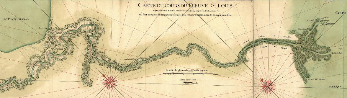
What prompted the Spanish urbanization effort was one of the most infamous events in New Orleans history — the Good Friday Fire of 1788, which charred the heart of today’s French Quarter. Within days of the disaster, the Gravier family, owners of the plantation immediately upriver of the city, realized this was an ideal time to subdivide their land for urban development, with so many blocks in the city proper strewn with ruins. The task of designing the subdivision went to city surveyor Carlos Laveau Trudeau, who sketched a grid of rectangular blocks (as opposed to the squares in the original city) and streets of varying widths (pedestrian alleys, narrow streets, and two wider arteries, Poydras and Julia) around a central plaza (later named Lafayette), all attenuated to the confines of the natural levee, from present-day Common Street up to roughly Howard Avenue. Trudeau called the subdivision the Suburbio (or Arrabal, meaning suburb) Santa Maria, which francophones called the Faubourg Ste. Marie, and anglophones would later call St. Mary.
As close as it was to the city proper, New Orleans’ first suburb was nevertheless inconvenient, because a muddy terre commune — that is, the commons fronting the city fortifications, which had to remain unobstructed as a firing line — prevented development from uniting the two grids. Once those defenses became obsolete in the early American years, the newly chartered City of New Orleans petitioned the U.S. government to transfer the commons to municipal ownership. On March 3, 1807, the U.S. Congress confirmed the city’s claim to the commons, while also stipulating that a 60-foot-wide right-of-way would be reserved for a navigation channel to be dug connecting the Carondelet Canal with the Mississippi River.
Within the triangular interstice bordered by Common Street and Customhouse Street (now Iberville), surveyor Jacques Tanesse laid out new blocks and connector streets along with a grand boulevard 171 feet in width — that is, two sidewalks 21 feet each, two roadways each 35 feet wide, and the canal bed at 59 feet. Completed in 1810, the Canal Street corridor and the adjoining “100 blocks” united the two sections of the growing metropolis. By the 1820s, Faubourg Ste. Marie had gained so many English-speakers that many people called it the American sector or quarter, counterpart of what folks variously called the French, Creole, or Latin quarter — today’s French Quarter. Within a decade or so, “St. Mary” would become increasingly commercial in its land use, and by the late 1800s, it would increasingly earn the name it has today: Central Business District. Let’s take a look at what Charles Franck photographed as his flying machine circled over that booming downtown of 1922.
1. Here we see Canal Street at the peak of its retail and service economy. Luckily for the city, the envisioned navigation canal of 1807 was never dug, allowing for its ample “neutral ground” (a jocular reference coined in the 1830s in reference to rival Creole and American factions) to be used for conveyances, including streetcar lines. The Canal Street intersection of Royal/St. Charles was often described as the “center of the city.”
2. The turreted building on the corner of Carondelet had originally been built in 1884 as the Pickwick Club until a fire in 1894 sent the Pickwickians packing for 1028 Canal Street. Architects restored the structure to house Fellman’s clothing store, which in 1918 became Feibleman’s, the occupant at the time of this photo. After Feibleman’s merged with Sears-Roebuck and moved to the Sears store on Baronne Street, the turreted building became a Stein’s discount clothier, a hotel, and a USO branch during World War II. The former clubhouse was finally demolished in 1948 to make room for the Gus Mayer department store.
3. Maison Blanche, one of New Orleans’ most famous department stores, operated on the corner of Canal and Dauphine for nearly 90 years. Previously housed in an ornate domed Victorian building on the same site, this pearl-white Beaux Arts complex opened in 1909, putting Maison Blanche in competition with Godchaux’s and D. H. Holmes as the city’s premier shopping emporium. In 1998, after so many downtown institutions had either closed or relocated, Dillards bought out Maison Blanche and closed the flagship store. Two years, the building reopened as the Ritz-Carlton Hotel.
4. Chess, Checkers, and Whist was built in 1890 as a clubhouse with offices and retail space for rent. One of a number of society clubhouses in this vicinity, the club’s corner cupola formed a landmark of the Baronne/Canal intersection, and a counterpart to the Pickwick Club’s turret. After Chess, Checkers, and Whist moved to Bourbon Street, workers razed the building in 1937 and replaced it with the streamlined Art Deco-style Walgreen’s, still in operation today as a flagship location of the national pharmacy chain. The pharmacy originally catered to patients of the many doctors and dentists whose offices were located in the upper floors of the Maison Blanche Building.
5. Here we see the Roosevelt Hotel when it was still the Hotel Grunewald, built in 1908 to face University Place. The fancy lodge had not yet expanded into the space of Grunewald Hall, which may be seen here facing Baronne, next to Chess, Checkers, and Whist.
6. The Tulane and Crescent Theaters, innovative twin playhouses designed by Thomas Sully and opened in 1898, hosted performances in an era when entertainment transitioned from musicals and plays, to vaudeville, to silent films, and finally to “talkies.” Its unusual lawn and crescent driveway on Baronne was replaced by the storehouses visible here. All were demolished between 1937 and the late 1940s to make room for the Shell Corporation Building, opened in 1952.
7. Here we see a rare aerial view of the former College of the Immaculate Conception after the institution had relocated uptown to become Loyola University, enabling Jesuit High School to operate here. Three years after this photo was taken, the former college was demolished to make room for the Pere Marquette Building, by which time Jesuit had moved to its current building on Carrollton Avenue. Note the original Church of the Immaculate Conception (“Jesuit Church”) to the right, built during the 1850s and completely dismantled and rebuilt during 1927-1929 to correct serious structural problems.
8. Last of the three grand hotels occupying this site since 1837, the third St. Charles Hotel opened in 1896, exhibiting an Italian Renaissance aesthetic designed by Thomas Sully. Last operated as the Sheraton-St. Charles, it was demolished in 1974 and replaced nine years later by the Place St. Charles skyscraper.
9. Designed by Favrot and Livaudais and completed in 1921, the 355-foot-high Hibernia Bank Building ranked as the tallest building in Louisiana until the Capitol opened in 1932, and tallest in New Orleans until 1962, when 228 Baronne exceeded it by seven feet.
10. Row of late-antebellum cottages face South Rampart Street, which at the time was known as the Harlem of New Orleans, famous for its African American music venues and night spots.
11. The Poydras Street Market, built in 1838 in the middle of an extra-wide section of Poydras Street, from Penn to South Rampart, offered every conceivable foodstuff and household goods via hundreds of open stalls, all under a pavilion-like roof with a picturesque wooden cupola. It was razed by 1932 to make room for vehicular traffic.
12. The Hotel De Soto, built in 1904 and originally known as the Denechaud Hotel, was among the few elegant commercial operations on Poydras, a street mostly dedicated to wholesaling and services in the maritime and light industrial sectors. It remains in operation as Le Pavillon.
13. Poydras Street was originally laid out at 74 feet, only slightly wider than Julia Street, when Carlos Trudeau first sketched the Suburbio Santa Maria in 1788. Planners in 1927 recommended widening Poydras to accommodate growing automobile traffic, and in 1965, in preparation for the upcoming Claiborne and Riverfront expressways, the Poydras widening project finally got underway. Every Poydras-facing building on the lower (right) side of the street, from Baronne to the river, was razed to create a width of 132 feet. After the Riverfront Expressway was cancelled in 1969, the widening effort soon took on a second purpose, as it afforded ample ground space with the right air-space zoning to allow for Houston-style petroleum-industry skyscrapers to be built. Within a decade or so, Poydras Street went from the blue-collar cousin of Canal Street to the address of white-collar professionals.
14. James Freret’s stunning Masonic Temple, opened in 1892, looked like a cross between a medieval castle and a Gothic cathedral. It even had a lofty spire and statue of Solomon, symbolizing the Masons’ professional legacy and civic-religious aspirations. Yet the building had serious structural problems, and shortly after this photo was taken, it was demolished and replaced by 1926 with a Modern Gothic-style Masonic lodge, now a hotel.
15. Commercial Alley was one of a number of pedestrian walkways either designed by Carlos Trudeau into the original Santa Maria street system in 1788, or cut through in the early 1800s, to creating valuable commercial real estate in an era when most people walked everywhere. Few of these alleys fared well in the age of automobiles.
16. “Newspaper Row” was the city’s premier printing and journalism district from the 1840s through the 1920s, home to numerous newspapers, printing shops, and publishing houses. Centered around the 300 block of Camp Street, the offices also extended into adjacent streets and walkways, including Commercial Alley, Natchez Alley, and Bank Alley (now Picayune Place). Later in the 1920s, the offices of The Times-Picayune moved to a new building facing Lafayette Square, marking the beginning of the end of Newspaper Row.
In a future installment of Streetscapes, we’ll fly around toward the rear of the Central Business District and peer into the “back of town.”
Streetscapes is written by Richard Campanella, a geographer with the Tulane School of Architecture and Built Environment and author of “Draining New Orleans,” “The West Bank of Greater New Orleans,” and “Crossroads, Cutoffs, and Confluences: Origins of Louisiana Cities, Towns, and Villages” (LSU Press). Campanella may be reached through richcampanella.com, [email protected], or @nolacampanella on X.