This story appeared in the February/March issue of PRC’s Preservation in Print magazine. Interested in getting more preservation stories like this delivered to your door? Become a member of the PRC for a subscription!
On a foggy morning 327 years ago, a French explorer learned a geography lesson that would forever affect our regional destiny. The explorer was Pierre Le Moyne, Sieur d’Iberville, along with his brother Bienville and crew; the informants were Native people possibly of the Quinipissa tribe; and the lesson came while struggling up the Mississippi River in longboats after anchoring in the Mississippi Sound.
“The Indian I have with me,” wrote Iberville on March 9, 1699, “pointed out to me the place through which the Indians make their portage to this river from the back of the bay where the ships are anchored. They drag their canoes over a rather good road (whose) distance…was slight.”
Iberville learned that in such a portage — that is, a short distance connecting two navigable waterbodies — one could circumvent the treacherous mouth of the Mississippi and proceed inland through Lake Pontchartrain and Bayou St. John instead. Nineteen years later, Bienville would capitalize on that lesson when he selected today’s French Quarter to establish New Orleans.
Researchers have concurred that the portage Iberville described in 1699 was today’s Bayou Road, extending from Gov. Nicholls Street to Bayou St. John. Among them were the late historian Richebourg Gaillard McWilliams, who translated and annotated Iberville’s Gulf Journals (University of Alabama Press, 1981), and myself, in one of my earlier works.
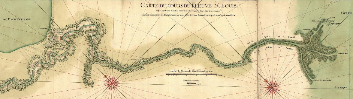
But a close reading of Iberville’s journal leads me to question whether the portage he described was precisely today’s Bayou Road. The evidence is in the meanders. Lacking discernable landmarks, Iberville relied on river meanders to mark his passage and measured his progress using the league, roughly three miles. Though much has changed on the lower Mississippi, major bends have generally retained their shape, allowing us to follow Iberville’s waypoints.
“Two leagues and a half abovethe mouth it forks into three branches,” Iberville wrote of the river’s bird-foot delta, after which he proceeded up the main middle channel, “being 350 to 400 fathoms wide,” or 2,100 to 2,400 feet wide, not too far off from its current width.
“From the forks up to 6 leagues inland,” Iberville continued, “the river is rather straight, running northwest five degrees north” — that’s the section along present-day Venice — “then it winds west for 2 leagues and again runs northwest,” meaning the bends from Boothville to Triumph to Buras.
On March 3, the expedition camped “at a bend it makes to the west, 12 leagues above the mouth, on a point on the right side [east bank] of the river, to which we have given the name Mardi Gras.”
On Ash Wednesday, Iberville progressed “8½ leagues, coming to several bends the river makes to the west-northwest and north-northwest,” meaning the Jesuit Bend stretch past Empire and Sulphur.
Fog slowed the expedition on Thursday, by which time Iberville observed how meanders that had previously “shifted from west to southwest” were now leaning “northwest and north,” implying the present-day Alliance and Woodlawn areas near Belle Chasse.
Conditions worsened on Friday, March 6, when “all morning there was fog and no wind,” such that the expedition progressed “with great difficulty” amid uprooted trees and strong currents. It reached “the first bend the river makes east-northeast,” meaning Braithwaite, then headed east, “at the end of which I made camp on the right side of the river,” around Caernarvon. “Today I made 6½ leagues.”
The twists kept coming on Saturday, March 7, when an exasperated Iberville summarized “that the river bends a great deal from northeast to southwest, through the north and the west. Over a distance of 2 leagues it will make two and three bends.” This is English Turn, a name coined later that summer when Bienville bluffed an enemy British corvette into retreating.
It’s tough to say exactly where the men spent the night of March 7, but journal entries indicate they had completely circumnavigated English Turn, putting their campsite around today’s Chalmette.
Strong headwinds on March 8 meant they “made only 4½ leagues and camped on the right side of the river. My men are getting very tired.” This puts Iberville in today’s Uptown New Orleans on Sunday night — past the future French Quarter site and its Bayou Road portage.
Which brings us to Monday, March 9, when Iberville wrote that “two leagues from the place where we stopped for the night,” he saw where “the Indians make their portage,” and went on to describe that “rather good road, at which we found several pieces of baggage owned by men that were going there or were returning.”
So, let’s add another six river miles (two leagues) to our Uptown campsite, and that puts Iberville on March 9 looking at the portage in today’s Elmwood/Harahan area — well upriver of where researchers had presumed the portage to be.
So where, exactly, was Iberville’s portage — or, more accurately, the portage pointed out by his Native informants?
I will readily acknowledge that, given the margin of error in estimating waypoints, and the imprecision of the league measurements, one could compile an itinerary that puts Iberville closer to the French Quarter/Bayou Road portage on March 9, as researchers have previously surmised. But it’s a stretch — or rather, a compression. That is, you must compress Iberville’s distances, meanders, campsites and other clues to “force” him to hit that target on that date. More likely, I believe, the portage he saw involved a shortcut to the Metairie Ridge, which also gets you to Bayou St. John and Lake Pontchartrain.
The Metairie Ridge is a slender natural levee created by the former channel of the Mississippi River before it lunged into its current route. By the 1690s, that diminished flow had become an abandoned distributary — that is, a sluggish bayou (parts of which still exist in City Park) whose upraised banks (today’s Metairie Road and City Park Avenue) allowed for passage through the swamps. Following that footpath got you to Bayou St. John and “the back of the bay,” meaning Lake Pontchartrain, Lake Borgne and the Mississippi Sound.
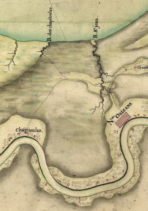
How to get from the river to the Metairie Ridge? Depending on seasonal conditions, there were two options. One is shown on the 1749 Saucier Map as a dashed line emerging from the “Chapitoulas Coast” near Elmwood and connecting with the Metairie Ridge near today’s Metairie Cemetery. There, the backslope of the river’s natural levee neared the Metairie Ridge such that, during dry conditions, one could walk from river to ridge.
A second option is found where the abandoned distributary had forked off from the Mississippi, just upriver from Harahan in today’s River Ridge. Here, travelers carrying pirogues and baggage (“portage” comes from porter, to carry) could walk from the riverbank onto the Metairie Ridge and onward to the bayou and bay (lake), exactly as that Native informant described. The Saucier Map also depicts another such portage farther upriver, at “Bayou Tigoutou” (likely Bayou Trepagnier) in today’s St. Charles Parish.
The Saucier Map illustrates the larger historical significance of what the French had learned from the Natives: that, by using portages, one could access the river without going up the river. These back-door shortcuts were so important that Natives had a word for them in the Mugulasha tongue: “imashaka,” meaning rear entrance, and written as Manchac — itself a back door (via Pass Manchac and Bayou Manchac) to Baton Rouge.
Iberville ascertained the portage he saw in March 1699 when he sailed into Lake Pontchartrain in early 1700. “I got to the mouth of the stream,” he wrote of Bayou St. John on January 17; “it is 20 yards wide, 10 feet deep, and 1 league long.” The next day he “went to the portage, which I found to be 1 league long, (traversing) a country of canes and fine woods, suitable to live in.” He had his men carry three canoes over the portage, today’s Bayou Road/Esplanade Ridge, and arrived “at a spot where the Quinipissas once had a village, 1½ leagues above this portage” — likely a reference to the area he visited the prior March, now Elmwood/Harahan.
Richard Campanella, a geographer with the Tulane School of Architecture, is the author of Draining New Orleans, The West Bank of Greater New Orleans, and Bienville’s Dilemma, and other books. A version of this material appeared in the New Orleans Times-Picayune in 2024 and is published here with permission. Campanella may be reached at richcampanella.com, [email protected] or @nolacampanella on X.