


This story appeared in the November issue of the PRC’s Preservation in Print magazine. Interested in getting more preservation stories like this delivered to your door monthly? Become a member of the PRC for a subscription!
When you drive Interstate 10 between the Superdome and the cemeteries, or West End Boulevard through Lakeview, you’re using a transportation corridor first created nearly two centuries ago by the forces of global capitalism.
New Orleans at that time represented a high-risk, high-reward investing environment. Living conditions were tough and death rates high, but opportunity abounded — for free white males, that is. The population had grown six-fold since 1800, surpassing 49,000 in 1830, which in turn more than doubled by 1840.
All those people needed food and construction materials, and the Lake Pontchartrain basin produced both. Its brackish waters and marshes supported game, finfish and shellfish; its bottom sediments yielded shells for paving and making lime; and the piney woods to the north yielded timber products, fine clay for bricks and a surprising amount of livestock. “Nowhere in the United States,” wrote Samuel R. Brown in 1817, are “hogs and cattle…raised in greater numbers than [around] Madisonville.” Eastward through the Rigolets could be found additional commercial opportunities, with Biloxi, Mobile, Pensacola and beyond.
Efficiently accessing these resources and destinations presented a constant challenge. Originally there was Bayou St. John and the Bayou Road, but this natural portage entailed an awkward break-of-cargo point where the twisting rivulet met the muddy road. In 1794, Spanish Governor Carondelet bettered that connection by having a channel excavated to the bayou. The Carondelet Canal helped speed cargo flows from lake to city, especially after the canal was privatized and improved in 1817.
Advertisement

In 1831, downtown investors created new lake access in the form of a railroad on Elysian Fields Avenue. Later nicknamed “Smoky Mary,” the Pontchartrain Railroad spurred transportation entrepreneurism region-wide. One group organized the Lake Borgne Navigation Company, while another planned a railroad to St. Bernard Parish. Not to be outdone, the Pontchartrain Railroad planned to extend its tracks eastward to Lake Borgne.
Yet another group of investors eyed Lake Pontchartrain and bristled, as its natural largesse flowed mostly into the more Creole neighborhoods of the lower half of the metropolis. Wanting a piece of the action for upper faubourgs, these Anglo-American financiers formed an “improvement bank” — that is, a corporation aimed at building private infrastructure, as opposed to a commercial bank (for merchants) or a property bank (for mortgages). This was an era when the federal government was too weak to build much transportation infrastructure throughout the growing nation, so the task often fell to the private sector.
Named the New Orleans Canal and Banking Company, the corporate charter called for a 60-foot-wide channel at least six feet deep, lined with levees, paralleled with a toll road and tow path, with a turning basin in the city and a harbor at the lake. The company would have exclusive rights to collect tolls for 35 years, after which the canal would revert to the state. It was a win-win for both sides, and the state legislature granted the charter on March 5, 1831.
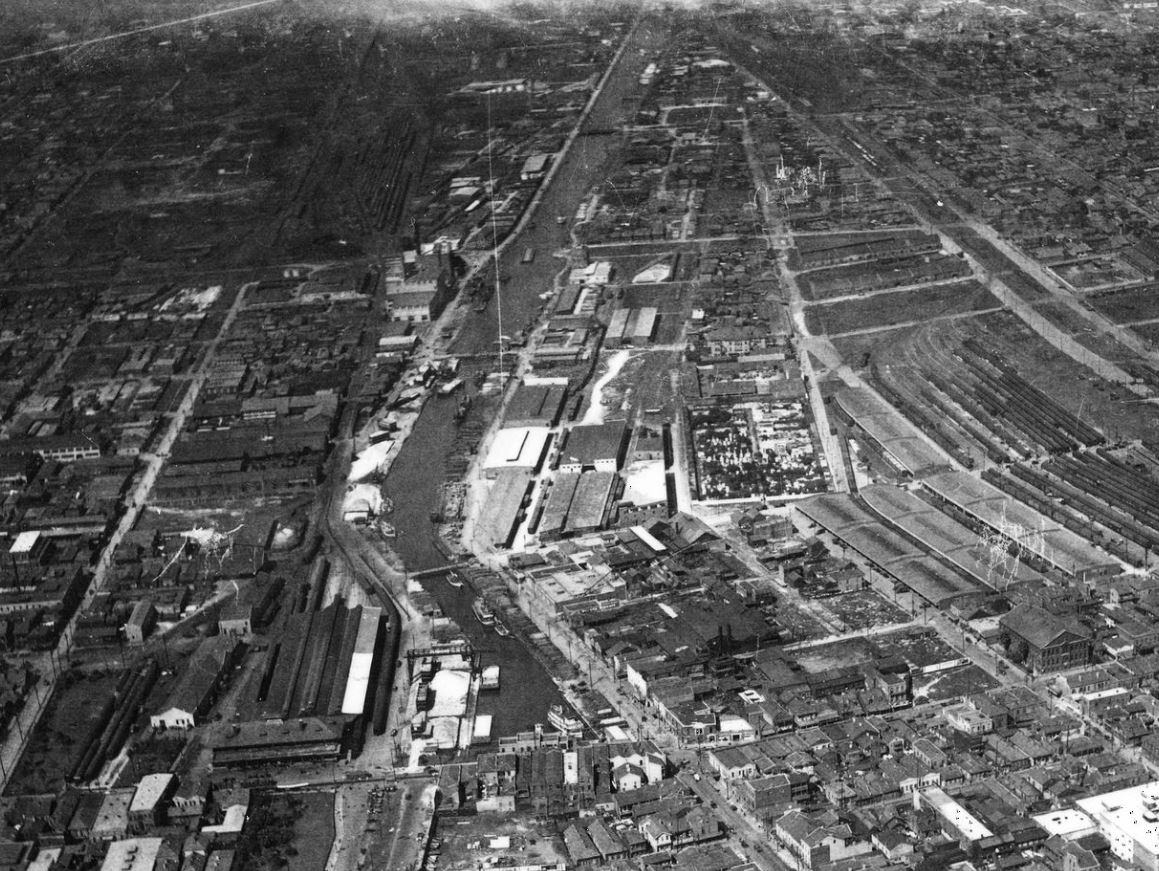
This rare aerial photo of the New Basin Canal’s turning basin was taken in 1922. Photo courtesy of The Historic New Orleans Collection, Charles Franck Collection.
A month later, the N.O.C.&B.C. began offering stock from an office on Royal Street. By early June, it sold an “unpreceded” 24,000 shares, resulting in a capitalization of $4 million, the equivalent of more than $100 million today. According to the National Gazette of Philadelphia, where the company would open a stock-transfer office, the enthusiasm stemmed from the “large purchase of land made by the Company, for the location of the [turning] Basin and two miles of the Canal.” Other offices would open in New York, Boston and London, making N.O.C.&B.C. truly a global enterprise.
Land acquisition was critical not only for rights-of-way and investor confidence, but also because the canal would raise the value of adjacent lots — and now was the time to scoop them up. Indeed, the company began “flipping” parcels as early as 1832, before digging even began, and profited four-fold from their resale, using the revenue to pay investor dividends.
The most valuable land surrounded the turning basin, the inland quay where vessels would dock. Named “Mobile Landing” to advertise its trade potential with the Gulf Coast’s second-largest city, the basin would be built at the crux of Triton Walk (now Howard Avenue) and Julia Street, a space occupied today by the Union Terminal parking lot and Loyola Avenue at the foot of the Plaza Tower.
The canal right-of-way would run 300 feet wide and 6 miles long in three angled segments. This was not ideal; better to have a straight run to the lake. But those two prior land acquisitions at each termini forced engineers to design two inflection points in between, where purchases and permissions were cobbled together from the Macarty family land and other parties in the rear of what would become Carrollton.
Advertisement
The final and most critical part of the project entailed labor. Whereas Spanish authorities had used enslaved workers to dig the Carondelet Canal, this private enterprise tapped into cheap Irish immigrant labor. Thousands of Irish “ditchers” were recruited and sent to the New Orleans backswamp.
Digging by hand, the workers excavated the channel in sections, using the fill to form guide levees and roads. They next removed the separating walls and let the water flow throughout. The first half of the canal, from Mobile Landing to Metairie Road (now City Park Avenue), was completed in August 1834, and the rest in 1835.
It is often told that upwards of 10,000 Irishmen perished in this effort, but this is likely an overestimate. The 1832-1833 cholera epidemic killed thousands of New Orleanians, including Irish workers, just as canal work got underway. Moreover, many victims were buried in a mass grave in the Girod Street Cemetery, which was all of two blocks from the basin. The collective memory seems to have conflated these two events, and oft-quoted narrative histories would later give traction to the high death toll. Lack of documentary or forensic evidence notwithstanding, the canal work was indeed arduous, and an untold number of ditchers suffered and died as a result.
There were financial problems as well. Newspaper reports in 1836 told of construction mismanagement, overspending and slow commercial activity at Mobile Landing. But once fully opened in 1838, the “New Orleans Canal” attracted a steady stream of vessels, and as shippers came to rely on the canal for their success, so grew the canal as a business. The company charged $0.375 per ton for passage and, by one account, made $405,563 in the first year alone, the equivalent of $10 million today. Freight — including sand, gravel, shells, bricks, lumber, firewood, charcoal, fruits, vegetables, game, fish and oysters — came up the waterway, while imports and merchandise flowed out the canal to Mandeville, Madisonville, Covington and beyond.
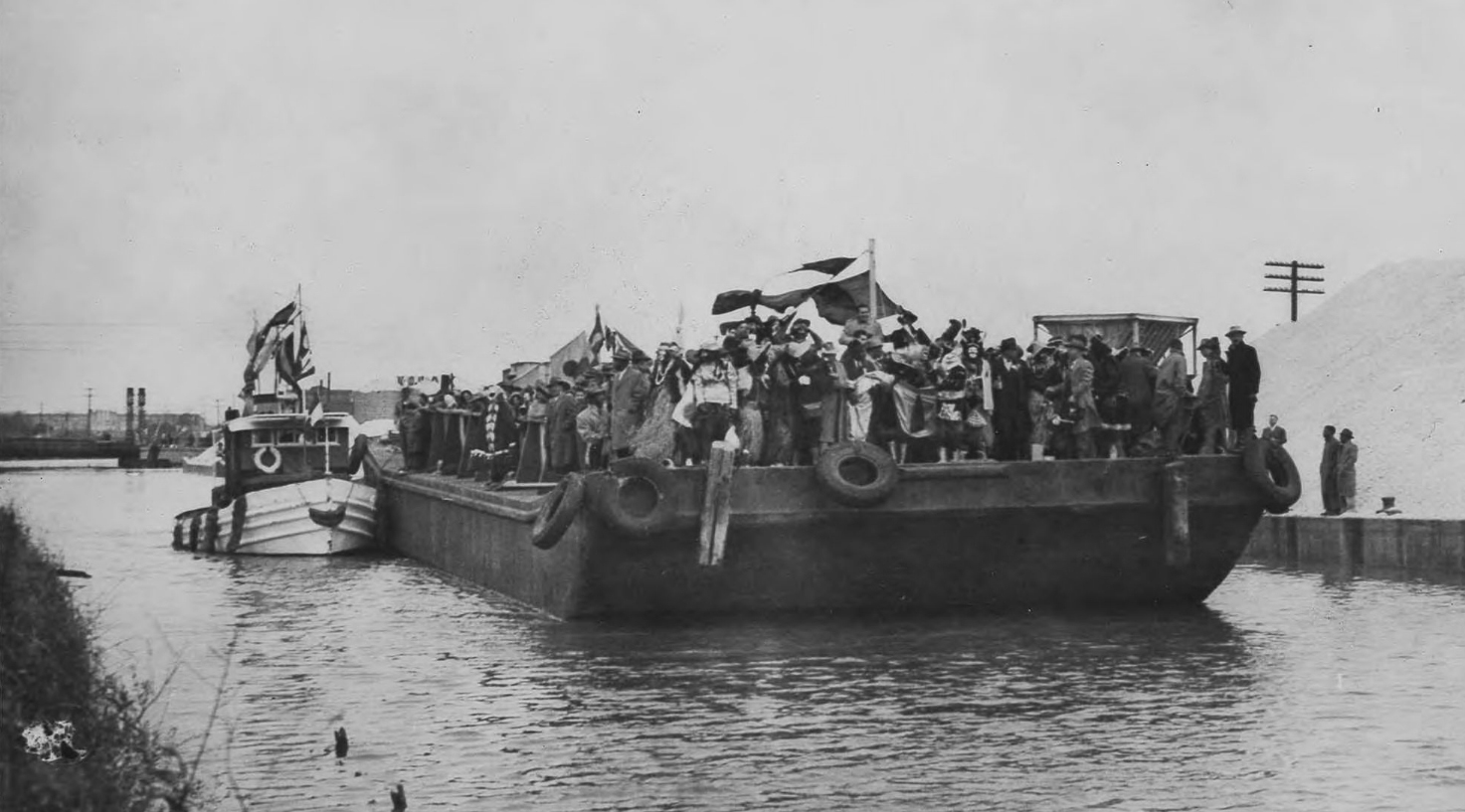
In 1949, Louis Armstrong, King of Zulu, arrived by barge on the New Basin Canal. Photo courtesy of the Louisiana State Museum.
Mobile Landing, meanwhile, became a bustling inland port, spurring industry and home-building in the Second Municipality. The shell road became a key cross-swamp artery and popular harness-racing track, while the jetty-protected harbor at Lake Pontchartrain would become a recreational getaway nicknamed New Lake End, to distinguish it from Milneburg (Old Lake End), its counterpart at the terminus of the Pontchartrain Railroad.
Here would arise hotels, restaurants, billiard halls, amusements, a yacht club and performance venues, which, in the 1870s, would get rebranded as West End. Because most urbanites knew the canal by its city-side turning basin, folks dubbed the operation the “basin canal” — specifically the “new” one, as opposed to the aging Carondelet Canal. Over time, the rival waterways became universally known as the New Basin Canal and Old Basin Canal.
The N.O.C.&B.C. would eventually get out of the improvements business and become a traditional financial institution. As planned, the New Basin Canal transferred to state control in the 1860s, and despite a dizzying array of court cases adjudicating everything from toll rates to shipping rights, the waterway remained vital. During 1893-1894, according to historian Joy Jackson, 3,367 luggers, schooners and tug-pushed barges plied the New Basin Canal, bearing 14 million feet of logs, 7 million bricks, 10,000 cords of fire wood, and huge quantities of charcoal, sand and resin. Thousands of historic houses still standing today incorporate canal-shipped materials, the wood having been milled at the many lumber shops (nearly two dozen in 1883) near the turning basin.
Advertisement

What spelled the end of the New Basin Canal were trucks, modern highways, the Industrial Canal and Intracoastal Waterway. These 20th-century conveyances enabled more cargo to flow more efficiently from broader hinterlands, while the canals of the 18th and 19th centuries came to be seen as traffic obstacles and neighborhood nuisances.
In 1936, the state passed a constitutional amendment to close the New Basin Canal. Filling of its turning basin began in July 1937, and a year later, the section to South Claiborne was covered. The remaining channel functioned until after World War II but was finally filled in by the early 1950s — just in time for construction of the Pontchartrain Expressway and Mississippi River Bridge (1958), for which the state-owned right-of-way made perfect space.
The Lakeview segment, meanwhile, became Pontchartrain and West End boulevards, and its unusually wide neutral ground — 300 feet, the width of the old canal right-of-way — today hosts a Celtic Cross monument to honor the Irish ditchers.
The only portion of the New Basin Canal channel still open today also is its youngest: the extension at West End, now between Lake Marina Drive and the Southern Yacht Club, which had been added as part of the Lakefront land-reclamation project of the late 1920s. Overlooking it today is the restored New Canal Lighthouse, continuing a legacy of light towers here dating back to 1839 and now serving as a museum of the Lake Pontchartrain Basin Foundation.
The main channel of New Basin Canal, meanwhile, is all but disappeared. Yet its geography remains forever part of the New Orleans cityscape — and the daily itinerary of thousands of metro-area motorists, as they drive I-10 between the cemeteries and the Superdome.
Richard Campanella is a geographer with the Tulane School of Architecture and author of Cityscapes of New Orleans; Bourbon Street: A History; Bienville’s Dilemma; and other books. Campanella may be reached through richcampanella.com, [email protected] or @nolacampanella on Twitter.
Advertisement