This story appeared in PRC’s Preservation in Print magazine. Interested in getting more preservation stories like this delivered to your door? Become a member of the PRC for a subscription!
“It is our unanimous opinion that this route should follow generally the New Basin Canal…and then continue along a new right-of-way roughly following Calliope Street to the Union Passenger Terminal, [with] a new Mississippi River crossing from Calliope Street to Algiers.”
Those words, penned by famed New York planner Robert Moses in his Arterial Plan for New Orleans (1946), steered the eyes of his clients in the Louisiana Department of Highways to the pathway that, 12 years hence, would become the Pontchartrain Expressway approach to the Mississippi River Bridge. Today, it comprises the Interstate 10 corridor from the cemeteries to the Superdome and onward to what is now the West Bank-bound span of the Crescent City Connection, the other span having been completed in 1988.
Moses’ plan came prior to federal interstate funding, so financing the expressway and bridge had to be figured out at the state and local level. Civic advocate and naval engineer Neville Levy proposed a tactic that had been used in the Northeast whereby a state authority would issue bonds for construction and charge tolls to users to defray costs for operations and maintenance. The idea resonated with state officials as well as New Orleans Mayor deLesseps “Chep” Morrison, who prioritized modernization initiatives in all forms. In 1952, the Louisiana Legislature passed the Bridges and Ferries Authority Act, which empowered commissions to build, operate and repair bridges, highways and ferries. The law spawned the Mississippi River Bridge Authority, on which were seated board members from the City of New Orleans, Jefferson Parish, the Louisiana Department of Highways, plus Modjeski and Masters as consulting engineers. Levy served as chair.
Planners, meanwhile, fine-tuned Moses’ earlier routing advice by plotting out a swath down the Calliope Street corridor (running top to bottom down the accompanying photo), plus adjacent streets for on- and off-ramps from Simon Bolivar Boulevard to Camp Street. In 1954, they began acquiring the targeted properties for clearance under eminent domain, using $3.5 million in compensatory funds. Work began on the bridge shortly thereafter, and in 1956 demolitions began on dozens of structures dating to the 19th century, the oldest being the circa-1815 Delord-Sarpy House (located where the National World War II Museum’s Campaigns of Courage pavilion now stands).
“Attention: All Buildings Must Go Immediately; Prices Right,” read a 1956 advertisement from the Crescent Demolishing and Lumber Company; “52 buildings to be demolished for state right-of-way Mississippi river bridge approach; single houses, double houses, steel buildings, brick buildings… lumber… pipes… blinds… sash and doors… iron railings — both plain and ornamental.” Among the condemned structures were homes, businesses, churches, schools, institutions, a firehouse and a convent.

Click images to expand
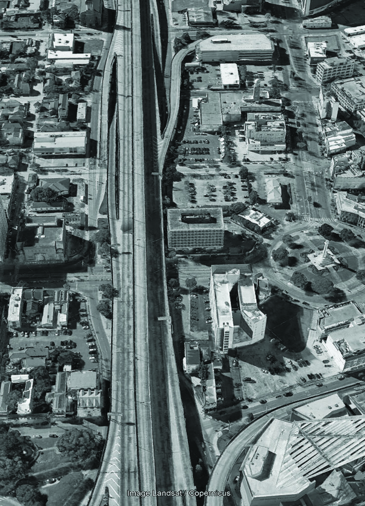
On the left, this photograph from 1950 shows the route urban planner Robert Moses recommended in 1946 for the Pontchartrain Expressway approach to the Mississippi River Bridge. The numbers on theimage correspond to the article’s descriptions of buildings that were demolished or affected to make way for the expressway and its ramps. THe photo was provided to Richard Campanella by Felton Suthon of Metairie courtesy of Modjeski and Masters and the Louisiana Department of Transportation and Development. On the right, a present-day image from Google Earth matches the 1950 image’s perspective.
Work proceeded through 1957 on the expressway and ramps, on the East Bank and in Algiers, which saw its share of demolitions along the Bringier Street corridor. The steel marvel that arose in between was described as the largest cantilever-and-truss highway bridge in the world, 1,575 feet in length, double that distance in its full approach. The Greater New Orleans Mississippi River Bridge opened on April 15, 1958, and forever changed both banks of the metropolis. The Pontchartrain Expressway itself changed the relationship between downtown and uptown New Orleans, by forming a dark and noisy division between neighborhoods that had previously feathered together rather seamlessly. Whereas New Orleanians historically used Canal Street in distinguishing between downtown and uptown, now that perception would shift to the Pontchartrain Expressway.
Like all progress, the project came with costs. They were born by people who lived and worked along the Calliope and Bringier corridors, who attended their schools and churches, and who had their lives upended so all the rest of us could get across the river expediently. The costs were also borne by those who saw cultural and urban value in aged structures — preservationists, who at the time were few in number but growing as a movement. Members of the Louisiana Landmarks Society met with bridge officials in May 1955 to make the case to save the Delord-Sarpy House. Their pleas fell on deaf ears, but the effort helped galvanize advocates and harden their resolve for the bigger battles of the 1960s and 1970s.
Other losses are visible in the accompanying photograph, which was taken by the Louisiana Department of Highways (now Transportation and Development) in 1950 along Moses’ proposed route. Digital copies of those photos were shared with me by engineer Felton Suthon of Metairie, who had worked for Modjeski and Masters for 15 years, and to whom I express gratitude. What follows are some of the salient buildings demolished six years after this photo was taken.
St. Paul’s Episcopal Church (marked 1 on photo), built in 1893 in the Richardson Romanesque style, replaced a Gothic-style predecessor which had been built in 1853 and lost to fire in 1891. Congregants in the 1950s were dismayed to learn that, even though both the elevated highway and its Camp Street on-ramp would miss their church, traffic still came too close for safety. Authorities gave time for the congregation to erect a new house of worship in Lakeview before razing St. Paul’s, making the 65-year-old church the last major bridge-related demolition on the East Bank. As for the Camp Street on-ramp, preservations won a years-long battle to remove it in 1994, making the demolition of St. Paul’s all more lamentable.
Across Margaret Place was a stately Greek Revival townhouse (2), probably dating to the late 1840s, which had served as quarters for Maj. Gen. Benjamin Butler during the Union occupation in 1862. It housed the Classical and Commercial College in the 1890s, and the New Orleans Public Library prior to the opening of the new main branch (6) in 1908. Now apartments, the townhouse was spared demolition by a matter of feet — a space that sealed the fate of its two neighbors seen to the right. The corner house with the hipped roof (3) had been the site of the St. Philips Episcopal Church in the 1870s, and later served as an office of the U.S. Engineers, today’s Army Corps.
The lot at 1521 Calliope St. (4) had a remarkably diverse legacy in the city’s educational history. Here, in the 1870s, had been built the Hebrew Girls School affiliated with nearby Temple Sinai (7), until the school was sold in 1881 to become the original Southern University, the co-education institution of higher learning for African Americans. When in 1886 Southern departed for a new campus on Magazine Street (and later for Baton Rouge), the schoolhouse served as the Margaret C. Hanson Normal School, as McDonogh School No. 21 (Boys High School No. 1, whites only), and finally as the Joseph A. Maybin School for vocational skills. Coincidentally, Levy, chair of the Mississippi River Bridge Authority, had attended classes here, and while inspecting the condemned building in April 1956, he found a brick in which he had carved “N. Levy” 50 years earlier.
Like St. Paul’s, the First Methodist Episcopal Church (5) on St. Charles Avenue survived the Pontchartrain Expressway, but not its ancillary arteries. Built in 1906, the eclectically designed Spanish-influenced house of worship met destruction in 1956 for the reconfiguration of Calliope Street as a service road running beneath the expressway. Driving Calliope from St. Charles to Prytania today puts you directly through the spaces of both the First Methodist Church and the schoolhouse behind it.
One year after the opening of the expressway and bridge, the wrecking ball swung on the New Orleans Public Library (6), designed by Diboll, Owen, and Goldstein and opened in 1908 as the Carnegie-funded main branch of the citywide system. Along with twin-towered Temple Sinai behind it (1873, at 7), the domed Jerusalem Temple (1920, at 8), and the onion-domed St. John the Baptist Church (1872, at 10), the copper-domed Greco-Roman-style library gave this part of the city a sort of Mediterranean-Byzantine skyline. What doomed the literary landmark was not the expressway, but another Morrison-era modernization project: the 1959 opening of the Civic Center on Loyola Avenue, which included a new Modernist building that remains the main branch of the New Orleans Public Library today. In 1961, workers completed the John Hancock Building on the site of the old library, designed by Skidmore, Owings & Merrill and later the headquarters of K&B.
Like the library, Temple Sinai (7) on Carondelet Street did not fall on account of the expressway, but nor did it benefit from economic conditions after the expressway opened. Designed by the local German-American architect Charles Lewis Hillger and built in 1873 by Peter R. Middlemiss, Temple Sinai cost $104,000, seated 1,500 people, and boasted two 115-foot-high towers of the Roman-Byzantine order. But as congregants gradually moved uptown, they decided to build a new synagogue in a more convenient location. They held their last service here in 1926, commenced the new Temple Sinai, and completed the move to 6227 St. Charles Avenue in 1928. The former temple was sold in 1929 and, for the next half-century, saw use as an office, storage facility, theater, and advertising studio. It was demolished in 1977, 19 years after the expressway opened.
The oblique angle of the buildings from 8 to 9 on the photo traces a trajectory that precisely aligns with the border separating the Saulet (Solet) and Delord-Sarpy (later Duplantier) plantations, prior to their subdivision (along with the adjacent Robin and Livaudais plantations) by Barthelemy Lafon during 1806-1810, creating today’s Lower Garden District and parts of Central City and the Irish Channel. The only relicts of this old plantation line still visible in the streetscape today may be seen in the off-plumb property line to the left of 1022 Loyola Ave., and within the parking lot where the old Temple Sinai once stood.
Next to St. John the Baptist Catholic Church (1872, at 10) was St. Mary’s Dominican Convent (11), where nuns from Ireland lived to educate girls at the parochial school that had been located at 12. The Dominicans moved their school uptown in 1881, and later to their present campus in the Marlyeville/Fountainebleau neighborhood, but the downtown convent remained in service until its demolition in 1957. The church narrowly evaded the swath of destruction, and in the aftermath, the monsignor had the onion dome painted in gold leaf, to herald its endurance to passing commuters.
In the next issue of Preservation in Print, we’ll examine frames taken farther inland along the New Basin Canal, as it too was prepared to host the Pontchartrain Expressway.
Richard Campanella is a geographer with the Tulane School of Architecture and author of The West Bank of Greater New Orleans; Cityscapes of New Orleans; Bourbon Street: A History; and other books. Campanella may be reached through richcampanella.com, [email protected], or @nolacampanella on Twitter.