This article, first published in November 2018 in The Times-Picayune|New Orleans Advocate, was republished in the March issue of PRC’s Preservation in Print magazine with permission. Interested in getting more preservation stories like this delivered to your door nine times a year? Become a member of the PRC for a subscription!
Imagine driving on Barataria Boulevard in Marrero and arriving on Napoleon Avenue in Uptown New Orleans moments later. Or coming along the Press Street tracks in Bywater and landing in Algiers.
Alternately, picture the Pontchartrain Expressway running over Julia Street in the Central Business District or on Race Street in the Lower Garden District.
These and other crossings were considered as Mississippi River bridge locations over the past century. Contemplating what our city might look like today had they happened helps us gauge the enormous role these engineering marvels play in our lives.
Bridges are connectors and nucleators of human activity; we build lives around them, and our lives are disrupted when they are. Consider, for example, the closure in 2018 of the damaged Sunshine Bridge, which upended commercial and residential life in the Donaldsonville area.
Now, as the nation considers investments in infrastructure improvements and evaluates the historical impact of highways on neighborhoods, it is an apt time to consider the role of bridges in the geography of New Orleans.
Advertisement

While the first span of today’s Crescent City Connection opened in 1958 and the second in 1988, the idea behind them was a long time coming.
Calls for a bridge at New Orleans began as early as the 1820s, and mounted as cities upriver spanned their channels starting in the 1850s. But the sheer size and power of the lower river, and the importance of its shipping industry, deferred serious initiatives.
This changed in the 1880s, by which time railroad interests were gaining power and needing to cross the river by a method more efficient than ferries. Engineering technology had developed to the point to enable bridge construction in deep, strong currents, sufficiently strong to bear freight trains and high enough to accommodate navigation interests.
In 1889, civil engineer Elmer Lawrence Corthell, who helped build jetties at the river’s mouth and a span at St. Louis, proposed a railroad bridge at Nine Mile Point, a mostly rural spot convenient to the Southern Pacific and Texas Pacific railroads. The concept gained momentum, even as competing proposals arose for different bridge designs in different areas.
Geological problems and financial issues, however, led to years of delays, and Corthell died in 1916.
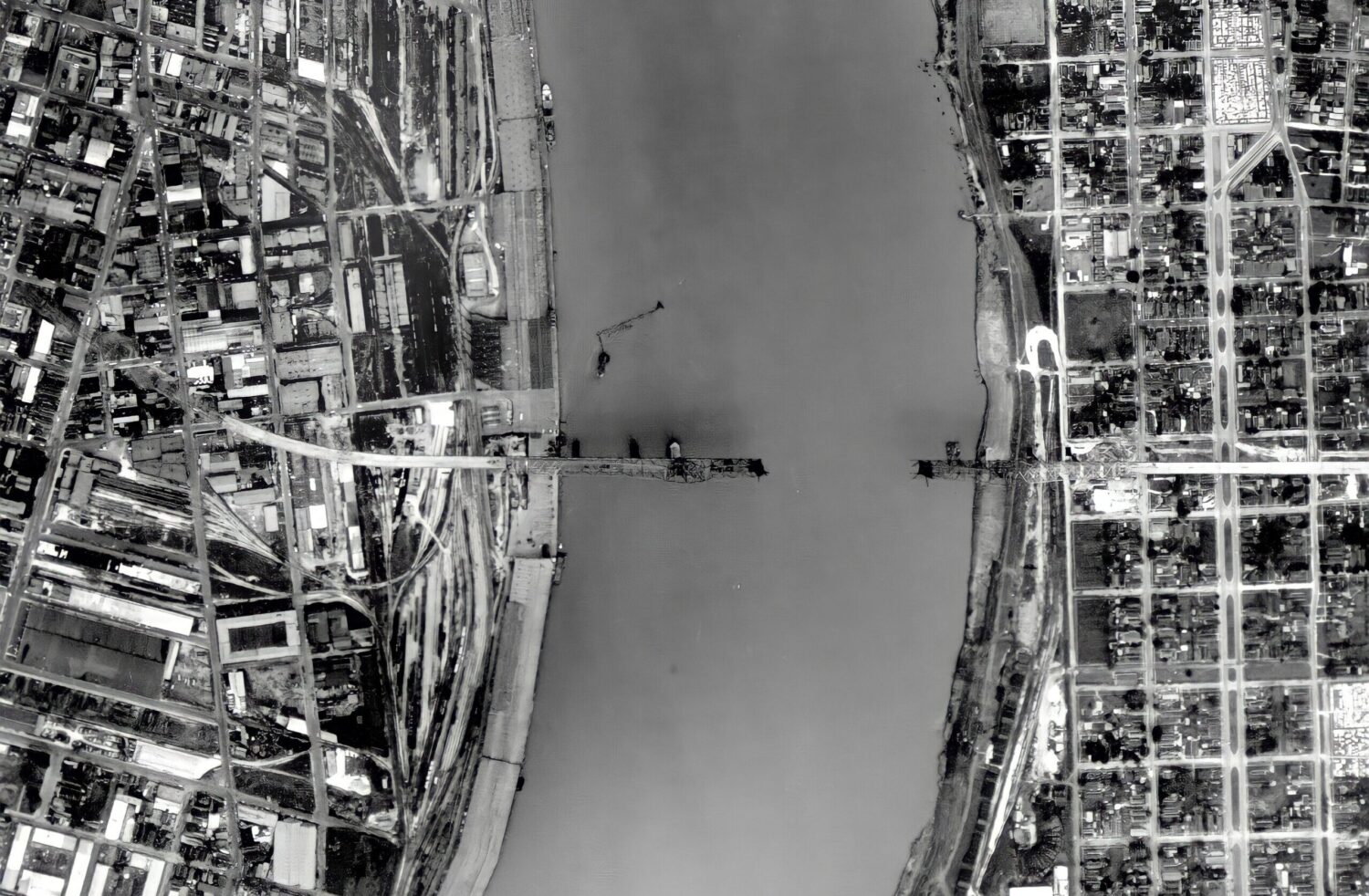
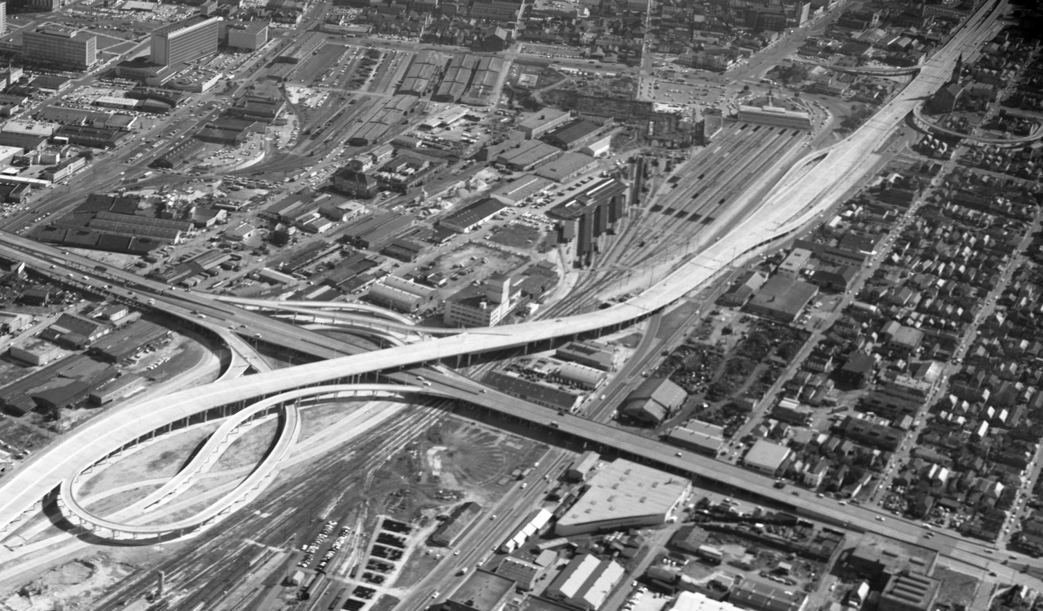 A 1957 aerial photo of the first Mississippi River bridge under construction, captured by Del Hall and the U.S. Air Force. Photo from Richard Campanella’s private collection.
That same year, the state legislature passed a constitutional amendment enabling the City of New Orleans to build, through its Public Belt Railroad Commission, a bridge at Nine Mile Point roughly where Corthell had originally recommended. The reason was also the same: this would be a bridge for railroads, not residents, and that’s where the tracks were.
The decision opened an opportunity to propose a bridge for residents. Entrepreneurs George Hero and Allen Hackett had previously succeeded in creating “drainage districts” on the West Bank, whereby taxes could be levied on land owners to pay for pump systems to reclaim swamplands. Having drained vast portions of Algiers, Gretna and Harvey in 1915, Hero and Hackett proposed in 1919 a privately financed bridge from Race Street to Gretna, leading straight into the newly developable land.
In 1925, the “Hero-Hackett Bridge” won the enthusiastic support of the Jefferson Parish Police Jury, a governing body that served as the legislative and executive government of the parish, but ran into delays when the War Department pressed for a higher vertical clearance. By the time it issued a permit, the stock market had crashed, and investment monies dried up during the Depression.
As for the Nine Mile Point bridge, planners contemplated the feasibility of a tunnel or a drawbridge, and even considered moving the bridge to Chalmette, present-day Bywater or Carrollton. They settled on River Mile 106.1, roughly where Corthell had indicated, and selected a high fixed-span cantilever-and-truss design.
Bridge engineers Modjeski and Masters lengthened the track span to create the 1.25 percent grade needed by freight trains, while still accommodating the War Department’s height requirement for shipping. To accommodate motorists, at the urging of populist Gov. Huey P. Long, two notoriously narrow auto lanes were added.
Work on the colossal project began in 1932 and ended shortly after Long, by then a senator, had been assassinated. When the bridge opened on Dec. 16, 1935, it was named in Long’s honor. It is often said that the reason the Huey P. Long Bridge is located so far from downtown New Orleans was because of Long’s disdain for the city in favor of rural Louisiana. While the outlying location of the bridge may well have pleased the governor, the real reason was the geography of railroads.
The “Huey P.” was indeed a boon to railroads and rural Jefferson Parish. But it sat too far from the urban core to affect the lives of most urban commuters. Thousands of New Orleanians continued to ferry across the river daily to Algiers ship-building jobs or Harvey and Westwego industrial plants.
Wartime employment made the West Bank bustle in the early 1940s, creating congestion on its 19th-century road network. With peace on the horizon, federal legislation in December 1944 created the Interregional Highway System, after which the Louisiana Department of Highways took stock of state needs and, among other things, suggested a bridge between Julia Street and Algiers.
 A 1957 aerial photo of the first Mississippi River bridge under construction, captured by Del Hall and the U.S. Air Force. Photo from Richard Campanella’s private collection.
Jefferson Parish officials disliked that option, calling Julia Street overly congested, but their real gripe was that the bridge lay entirely within Orleans Parish. What they and many state authorities wanted was a revival of the old Hero-Hackett proposal, from Race Street to Perry Street in Gretna.
To shed light on the options, the highway department in 1946 brought in an outside expert: Robert Moses, the lordly urban planner who, from the 1920s to 1960s, would radically reconfigure New York City.
In his influential Arterial Plan for New Orleans, Moses observed that “the natural area of residential expansion at New Orleans is in the direction of Algiers and Gretna.” To reach it, he proposed a “Pontchartrain Expressway” and “Waterfront” (later renamed Riverfront) Expressway to merge onto a new Mississippi River bridge and connect with a grade-level expressway on the West Bank.
Because the Pontchartrain Expressway would follow the soon-to-be-filled state-owned New Basin Canal, Moses’ bridge would have to cross from downtown to Algiers; Gretna would be too far upriver.
Would Julia Street work, as previously proposed? No, because Moses also planned to unify the various downtown passenger train stations into a “Union Passenger Terminal,” which had to be on Julia Street — thus an expressway could not also be there.
Moses instead placed his proposed span to run from Calliope Street (present-day John Churchill Chase) to Lamarque and Socrates streets on the West Bank.
In 1952, the State Legislature passed the Bridges and Ferries Authority Act and created the Mississippi River Bridge Authority, which would spearhead planning and construction after deciding on site selection.
Advertisement

One of the authority’s consultants pointed out that the foot of Thalia Street had an abandoned train ferry and no wharf, and thus could be acquired cheaply. The authority debated Calliope versus Thalia and concluded that a bridge at Calliope, being longer, would increase costs by $20 million. So the route was finalized at the Thalia-Bringier Street crossing, 95.7 miles up from the mouth of the Mississippi.
After six long years of design, expropriations, land acquisition and construction of the bridge as well as the Pontchartrain and West Bank expressways, the Greater New Orleans Mississippi River Bridge partially opened one minute after midnight on April 15, 1958. A total of 17,584 vehicles crossed on the first day.
As expected, New Orleans’ first river bridge was a hit. Within a few years, more than 35,000 vehicles crossed daily, and after tolls were lifted in May 1964, usage jumped to 52,000 per day. That same year, officials announced an ambitious “Outer Belt” encircling the entire metropolis, including bridges at Chalmette to Algiers, from Napoleon Avenue to Marrero, and from Destrehan to Luling, all connected by a “Dixie Freeway” along the southern fringes of the West Bank.
By this time, the West Bank had become an economic entity unto itself, with more commuters circulated on their side of the river than crossing to the other. Traffic clogged the numerous intersections along the grade-level West Bank Expressway, and in 1977 work commenced on elevating it.
A year later, planning began on what was officially called the Greater New Orleans Mississippi River Bridge No. 2. Once again, a number of routes were considered, including Press Street to Algiers, Causeway Boulevard to Nine Mile Point, and most controversially, Napoleon Avenue to Barataria Boulevard.
But by now, new sensibilities were pumping the brakes on the arterial euphoria. They started with the stunning preservationist victory in the cancellation of the Riverfront Expressway in 1969, and progressed with the cancellation of the Dixie Freeway in 1977 over environmental concerns. Preservationists and planning advocates particularly inveighed against the Napoleon Avenue option. Eventually, only partial segments of the Outer Belt would be built, namely Interstate 510, Interstate 610, Interstate 310 and the Hale Boggs (Destrehan-Luling) bridge.
When the planners got to siting the second span of the downtown bridge, they determined it made more sense to double-down on the existing right-of-way and capitalize on the ongoing augmentation of the West Bank Expressway. Other options were deemed “not feasible” or “not prudent.”
In fact, years before the state legislation was passed to finance the second bridge, consultants had leaned toward this “Parallel to Existing” option. As early as January 1973, Robert Tannen, head of the planning division of Curtis and Davis Architects, told The Times-Picayune that “consultants’ recommendation on a new bridge will be within the corridor [or] general vicinity of the existing Mississippi River bridge.” The engineering firm Modjeski and Masters described the envisioned span as “a new, high-level, multimodal bridge…located about 400 feet downstream and parallel to the existing [bridge].”
Why 400 feet? Were the spans any closer, soil-pressure “bulbs” associated with the pier caissons might overlap and cause tilting. Were they any farther apart, land requirements for the approaches would expand, driving up costs and complicating ramp placements. Four hundred feet of separation also allowed barge-mounted derricks to move safely among both sets of piers, and minimized the chances that a catastrophic accident, like a vessel collision, would damage both bridges.
This put the crossing at Calliope to Lawrence streets, a route deemed “viable” in that it minimized historical and environmental impacts while aligning well with existing expressways, and “prudent” in that it kept land acquisitions costs to a minimum and linked the most congested spots on both banks.
It took a solid 10 years to get from that 1978 decision to the Sept. 30, 1988, dedication ceremony of what would later be renamed, together with its 1958 counterpart, the Crescent City Connection. Said Algiers representative Francis Heitmeier that morning, “[t]oday, the West Bank will begin a new era in transportation and economic development, and we’ll take our place as the best bank in the entire state of Louisiana.”
Denizens of either bank debate whose side of the river is better, but all can agree that the bridges that unite us — where they are, and where they might have been — play an outsize role in how we occupy and experience this Mississippi-straddling metropolis.
Richard Campanella is a geographer with the Tulane School of Architecture and author of The West Bank of Greater New Orleans; Cityscapes of New Orleans; Bourbon Street: A History; and other books. Campanella may be reached through richcampanella.com, [email protected], or@nolacampanella on Twitter.
Advertisements