This article was originally published in The Times-Picayune/New Orleans Advocate, and was republished in the June issue of PRC’s Preservation in Print magazine with permission. Interested in getting more preservation stories like this delivered to your door nine times a year? Become a member of the PRC for a subscription!
Cities in hurricane zones face vexing questions. How many strikes can they withstand and still rebound? Relatedly, how many evacuations can they endure and still remain viable?
I’ll leave that first question for others, but I suspect the answer to the second question is, only so many.
If evacuation becomes a lifestyle requirement, the annual threat of total life interruption will scare away many current and would-be residents, regardless of storm outcomes. Young families, educated youth, workers, new investments, relocating companies — in a word, all that constitutes opportunity — will look elsewhere. New Orleans might live on as a destination for tourists, but it would cease to be a living city.
Is there an alternative to evacuation? New Orleans history offers some insights.
Ask folks of a certain age about hurricanes past, and you will likely hear stories of huddling with neighbors in local public buildings. Few evacuated, and most couldn’t anyway.
During the Great Storm of 1915, for example, thousands of occupants of small wooden houses took shelter in big sturdy brick neighborhood public schools, many of which still stand. Evacuation wasn’t an option. Coastal residents strove to get into New Orleans, knowing it was the safest alternative.
Likewise for the Hurricane of 1947, Hurricane Flossy in 1956, and Hurricane Betsy in 1965. With more than a half-million residents and most households still without private cars, a mass exodus was neither possible nor even envisioned. Instead, New Orleanians walked to designated public buildings, which doubled as aid and distribution centers.
When the threat passed, they walked home, secured their properties, reopened their businesses and schools, and got back to living.
The ad-hoc local-sheltering tradition was imperfect, and I don’t mean to idealize it. But it had key benefits, and chief among them was that it enabled a speedy return to normalcy, without the logistical mayhem of costly car-based evacuations.
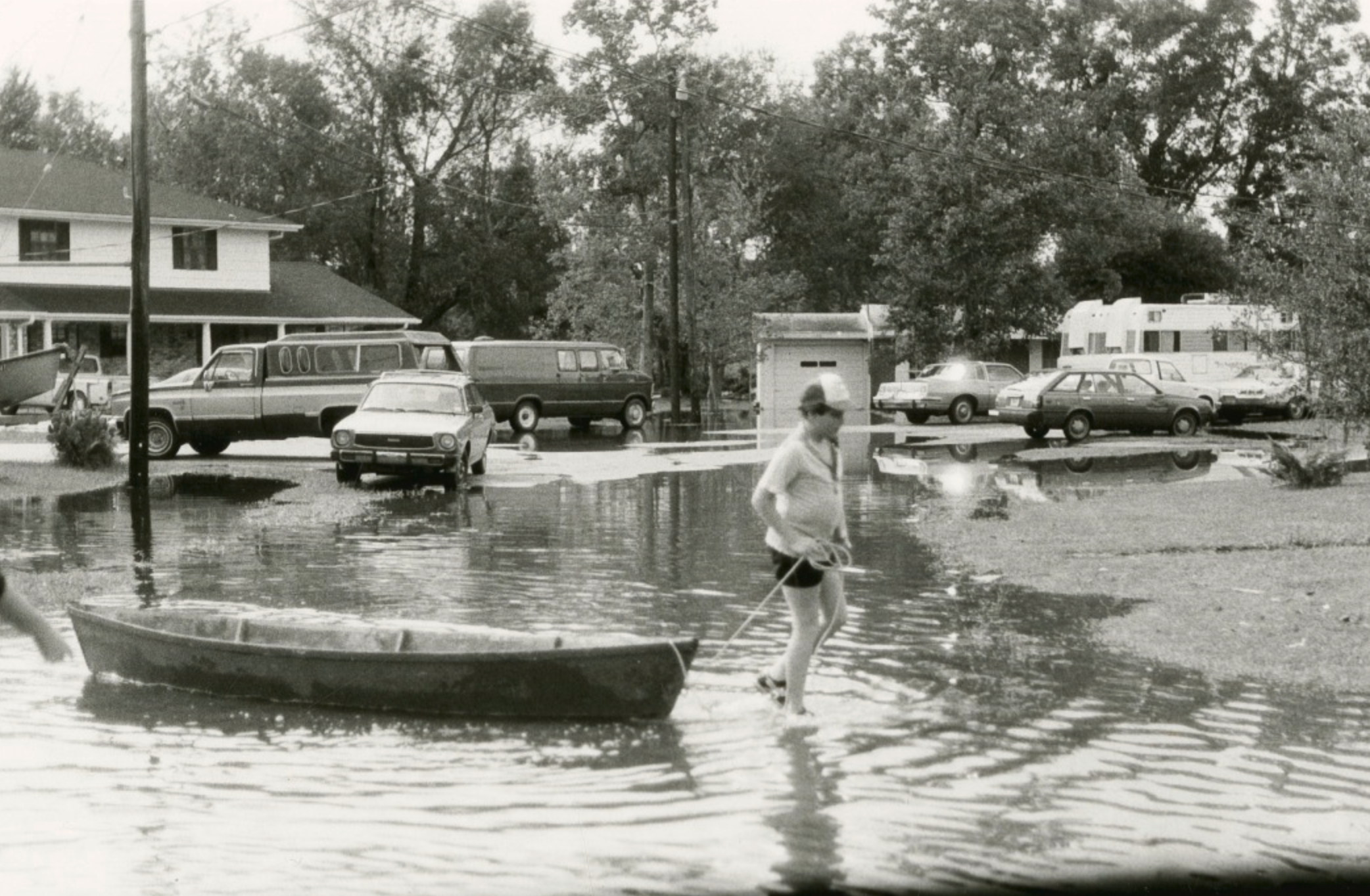
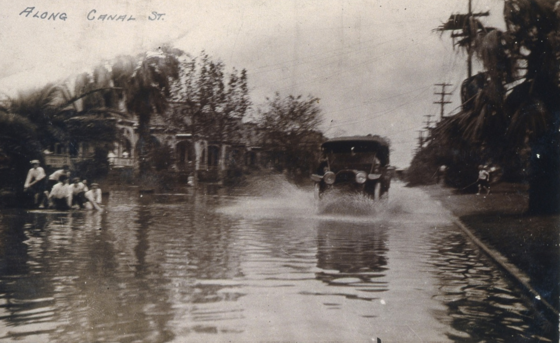
Photo 1: A car drives through floodwater on Canal Street after the Hurricane of 1915. Photo courtesy of The Historic New Orleans Collection. Photo 2: A man pulls a boat through floodwaters following Hurricane Juan in 1985. Photo courtesy of The Historic New Orleans Collection.
Local sheltering also adeptly handled the challenge of “tough call storms” — those weaker vortexes that could present a threat, or stronger ones that might veer away — because it maximized the window for a stay-or-leave decision and minimized the costs of the latter. If you decide to leave at the last minute, you just walk your family down to junior’s school, bedrolls and boardgames in hand.
So, what became of the local-sheltering tradition?
Following Hurricane Camille in 1969, a lull ensued in tropical activity, and only a few minor storms struck in subsequent decades. By the time things heated up again in the mid-1990s, conditions had changed.
Within the metropolis, thousands had resettled in low-lying suburbs, increasing human exposure to hurricane hazards, while leaving the urban core increasingly impoverished, troubled and vulnerable.
Interstates now crisscrossed the region, and a majority of households owned vehicles. (But not all: More than a third of African American residents of pre-Katrina Orleans Parish did not own a car, according to the 2000 census.) Those families with resources were now more inclined to hit the road and evade storms as individualized household units, rather than huddle with “strangers” in gloomy public buildings.
Advertisement

Meanwhile, vital city infrastructure had aged, and an erratic hodgepodge of under-engineered levees made the metro area — which since around 1900 had subsided below sea level, thanks to mechanized drainage — that much riskier.
Beyond the metropolis, coastal wetlands had eroded, sea levels had risen, and a labyrinth of navigation channels and oil and gas extraction canals had been scoured through marshes, inviting storm surge inland.
No longer was New Orleans a refuge for coastal denizens. It wasn’t even safe for residents. In response, emergency planners adopted a new strategy: evacuation.
Hurricane Georges in 1998 was the first big test for evacuation, and it showed much more planning was needed for it to work. The traffic jams were horrendous, and when the storm veered eastward to Mississippi, the whole costly interruption left a foul taste. That’s a major problem with evacuation: It doesn’t handle false positives well.
I say this not to fault the leaders who make these tough decisions, but to emphasize that the total life interruption attached to a false-positive evacuation — including the dangers of driving hundreds of miles in an overloaded clunker searching for gasoline and hotels — is not a trivial externality. It’s a weighty variable in long-term metropolitan viability.
After Hurricane Georges, planners doubled down on the evacuation strategy, devising a complex “contraflow” system to open inbound interstate lanes to outbound traffic. But as Hurricane Ivan threatened in 2004, traffic jams again ensued, and the storm again veered eastward, this time to Alabama. Another false positive.
And what of all those households without cars, roughly one in four? “Shelters of last resort” were made available, but they were a reluctant afterthought, with more effort going to dissuading their use than keeping users safe and supplied.
Then Hurricane Katrina approached in 2005. With over two days of warning time, a mandatory evacuation was called, with contraflow and recent learnings all in place. The exodus went reasonably well, and the decision to evacuate — this time a true positive — saved many lives, as federal levee failures led to catastrophic flooding. But the “shelter of last resort” system was an utter failure, as thousands of people found themselves trapped at the Superdome and Convention Center without adequate supplies. What resulted is a dark chapter in recent American history.
The Katrina catastrophe valorized the evacuation strategy and maligned any notion of local sheltering. In its wake, New Orleans developed the City-Assisted Evacuation Plan, which uses a fleet of buses and a network of pickup locations called Evacuspots to shuttle those without vehicles to statewide shelters during a mandatory evacuation.
Advertisement

But consider the shortcomings of (most) evacuations. During the exodus from Houston for Hurricane Rita in 2005, more deaths occurred on the road than by wind, rain or surge. Three years later, the mandatory evacuation of New Orleans ahead of Hurricane Gustav — a wise move given tenuous post-Katrina levees — nevertheless caused weeks of disruption.
Then came Hurricane Isaac in 2012, Zeta in 2020 and now Ida in 2021. All three were not enough of a threat to warrant mandatory evacuation, but enough of a blow to down power lines and leave hundreds of thousands stranded at home without electricity in subtropical conditions. Lack of power often leads to weak or no water pressure, limited drainage and sewerage, and an inability to extinguish fires.
Evacuation works when it’s an easy call, like Katrina or Gustav. But for those more-frequent tough calls, like Georges, Ivan, Isaac and Ida, as well as Isidore and Lily in 2002 and Cindy in 2005, we need an alternative.
That alternative, I believe, is an updated version of the historical local-shelter approach — only now, instead of old schools, we would build specially designed local sheltering centers, raised well above base flood elevation, positioned strategically, with their own generators and supply docks for intermodal deliveries. Inside would be air-conditioned communal spaces, semi-private sleeping quarters, food, water, sanitation, power, communications, basic medical facilities and security.
Like the best of multi-use infrastructure, these facilities could serve as civic gathering spaces from autumn through spring and transform into sheltering bunkers during storm season. They should be beautiful, useful, friendly and iconic; they should not be “last resorts.”
Sheltering centers would not have to built everywhere; start in the neighborhoods that want or need them the most, build a pilot, and proceed incrementally. Some can be co-located with hospitals like the University Medical Center or military facilities like Federal City or the former F. Edward Hebert Defense Complex on Poland Avenue, an empty compound perfectly situated on high ground in the Ninth Ward, with access by road, rail, river and helicopter.
How might a local sheltering center work during a tough-call storm like Ida? Let folks evacuate if they want (about half will) and open the fully operational center to residents who live within a certain predetermined perimeter (most will stay home). After the storm and amid the likely blackouts, allow users to come and go as they please, to check on their properties, clean up and reopen businesses, knowing they’ll have basic services for the week ahead. As utilities are restored, the centers can be used to lodge out-of-town recovery workers, but they should not be perceived as long-term temporary housing.
With a changing climate imbuing unpredictability into severe weather — look at how Ida intensified as it approached Louisiana and ended up releasing devastating floods in the New York City area — communities need a wider range of alternatives to the go/no-go evacuation decision. Local sheltering centers can provide a third option, reducing the stakes of a false positive while keeping the evacuation strategy in place.
I am not one for pie-in-the-sky “visions,” and I acknowledge limited budgets and other infrastructure needs. But tally up the true costs of evacuation, consider the likelihood of more severe weather, and factor in that vexing viability question, and a return to local sheltering may be the safer and cheaper alternative to a permanent evacuation lifestyle.
Richard Campanella is a geographer with the Tulane School of Architecture and author of The West Bank of Greater New Orleans; Cityscapes of New Orleans; Bourbon Street: A History; and other books. Campanella may be reached through richcampanella.com, [email protected], or@nolacampanella on Twitter.
Advertisements