This story appeared in the November issue of PRC’s Preservation in Print magazine. Interested in getting more preservation stories like this delivered to your door nine times a year? Become a member of the PRC for a subscription!
by Valerie Feathers, Abigail Bleichner and Diana Greenlee
Louisiana Archaeology Month went digital this year as the Louisiana Division of Archaeology and the Poverty Point World Heritage Site teamed up to create a virtual StoryMap exploring the use of waterways as prehistoric transportation routes. In particular, the creators focused on a single component of the site: stone material.
The Poverty Point World Heritage Site is unlike any other archaeological site in the world. It is the only place where archaeologists find both constructed semi-circular ridges and mounds in addition to a 600-year-long sedentary hunter-gatherer lifestyle (1700 to 1100 BCE). For 600 years, the American Indians who lived at the site moved more than 100 million basket loads of earth (weighing about 50 pounds each) to create this unique cultural landscape while hunting, fishing and gathering natural resources for their survival.
Advertisement

Although the monumental nature of the site is impressive in itself, Poverty Point is widely recognized for its vast array of artifacts. While the people of Poverty Point undoubtedly used wood, bone, cane and other locally available, but perishable, materials, the vast majority of artifacts from the site are made of either stone or fired loess. Loess (pronounced “luss”) is a sediment consisting of windblown silt from the Mississippi floodplain that was deposited on the Macon Ridge thousands of years ago. A variety of fired-earth objects (e.g., Poverty Point objects, tubular pipes, decorative objects and figurines) and pottery were made from the local sediment. Stone does not occur naturally at the site, and the material for the many thousands of stone artifacts had to be imported.
Rivers were (and still are) commonly used as a transportation route for people and goods. In addition to providing an abundance of dietary resources, rivers allowed for the relatively easy transport of heavy items, such as hematite, magnetite, galena, schist, quartz crystal, steatite, copper, greenstone and sandstone, to name a few. American Indians at the site imported an estimated 78 U.S. tons of rocks and minerals which were used for making tools and ornaments. The Mississippi River system was the most efficient way to move that much material.
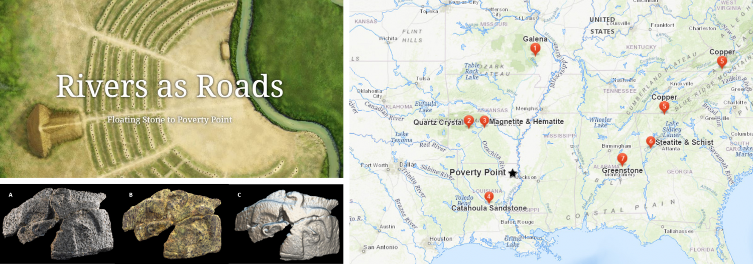
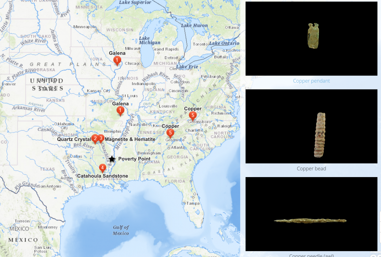
LEFT TOP: Poverty Point World Heritage Site StoryMap LEFT BOTTOM: A) Photograph of original artifact, B) 3D scan of original artifact (color variation is a result of the scanner), C) Matcap (or material capture) of the 3D scan showing the object’s shape. RIGHT: Map of stone sources.
This Poverty Point StoryMap highlights the Mississippi River watershed and the origins of the stone recovered at Poverty Point. Created as an interactive presentation for the 2020 NOLA River Fest, the Poverty Point StoryMap incorporates several different forms of digital technology, including mapping in ArcGIS, photography, website integration and 3D modeling.
The authors used a DSLR Canon camera and a light box to photograph the artifacts. A NextEngine Laser Scanner captured the 3D images of the artifacts, which were then processed using the Scan Studio software. The authors uploaded the final 3D models to Sketchfab, an open source platform for 3D models. The photos and 3D models of the artifacts were then linked to the geographical sources of the stone. Those source locations are marked by numbers on the StoryMap.
Advertisement

The StoryMap creation began once the various project components were completed. Staff utilized ESRI’s ArcGIS Online and ArcGIS StoryMaps platforms to construct an interactive and immersive web experience using both publicly accessible data and content created specifically for this presentation. ESRI StoryMaps allow creators to combine maps, narrative text, images and other multimedia content to produce a geographically driven story. Users are able to interact with the StoryMap in ways that traditional webpages cannot support.
Users are presented with an array of information and have several different exploration options as they scroll through the StoryMap. There are artistic renderings of the site and the daily life of its peoples, embedded texts, an illuminating informational video, maps of the Mississippi River Watershed and the sourced stone material, and photographs and 3D models of artifacts. The interactive nature of the StoryMap allows viewers to easily navigate and engage with the multiple types of information.
The Rivers as Roads: Floating Stone to Poverty Point StoryMap can be found on the Louisiana Division of Archaeology’s website here – or scroll to the bottom of this page to see the embedded StoryMap.
If you have any questions or comments, contact [email protected].
Advertisements