This article initially appeared in The Times-Picayune/New Orleans Advocate and was reprinted in the December issue of PRC’s Preservation in Print magazine. Interested in getting more preservation stories like this delivered to your door nine times a year? Become a member of the PRC for a subscription!
In a city replete with famed streets, scenic avenues and poetic street names, one particular artery excels at being obscure, nominally insipid, marvelously intermittent, and sometimes barely even a street.
Welcome to world-unfamous Front Street.
Perhaps you never heard of Front Street. Maybe you’ve seen its dead-ended segments in online maps. Uptowners know it as that on-again, off-again opportunity to drive parallel to the Mississippi riverside of Tchoupitoulas, where on the 3900 block and the 5800-5900 blocks may be found a smattering of residents. They’re among the few folks with a home address on South Front Street.
There’s also a North Front, which has the distinction of being the least-known street with the fewest structures in what is otherwise the city’s most famous neighborhood, the French Quarter.
Though it once spanned nearly six miles and served as the city’s “river road,” today Front Street is in relic form, both a victim and survivor of incessant riverfront land-use dynamics.
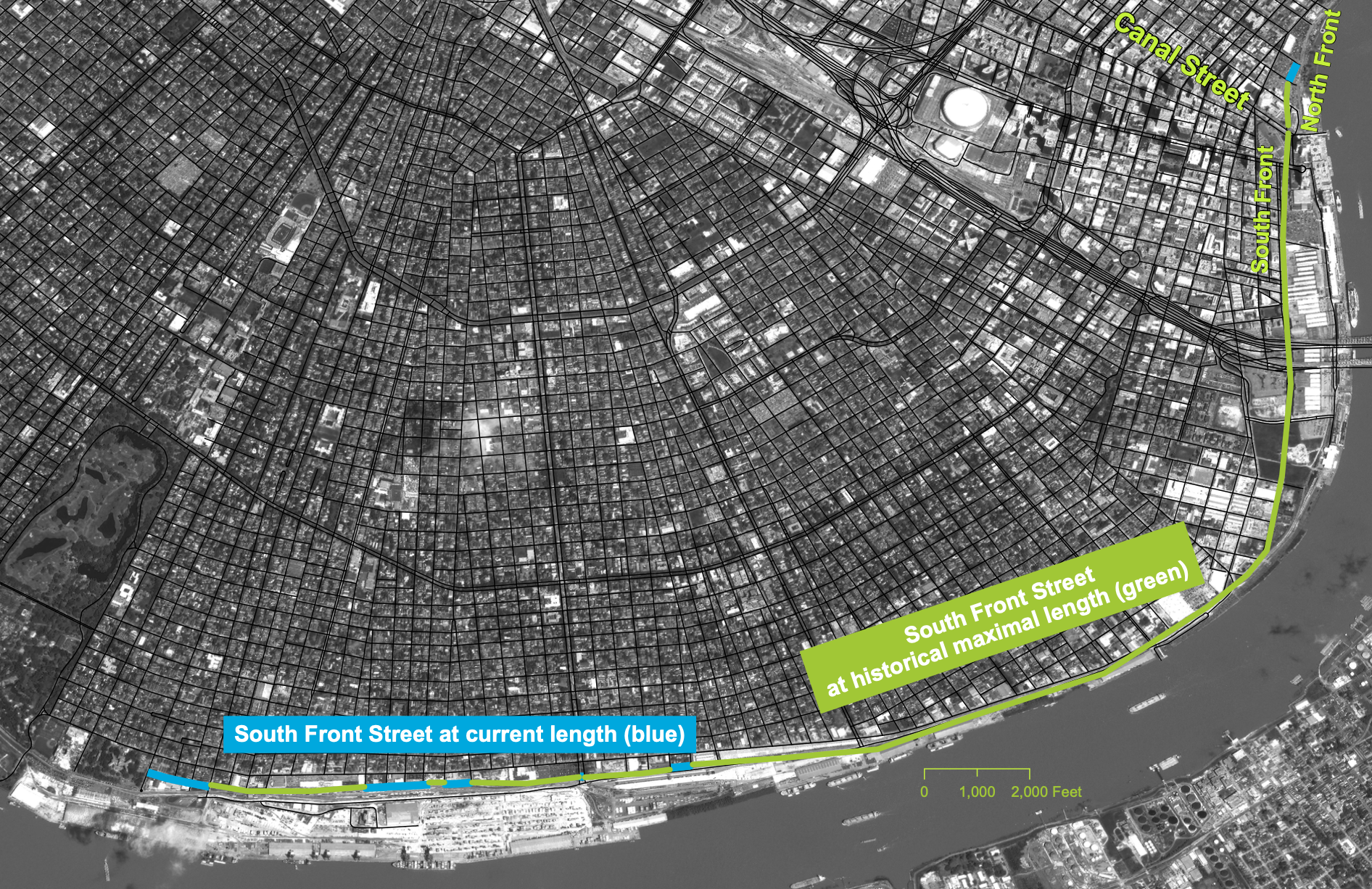
Map by Richard Campanella
Indeed, riverfront dynamics gave rise to Front Street.
“Front,” you may have noticed, is not a French, Spanish or indigenous name, indicating it was coined during New Orleans’ American administrative era. So, too, Commerce Street, North and South Peters streets and Fulton Street, not to mention now-gone Water, Delta and Clay streets.
All these American-named arteries had a singular geography: they would occupy the sandy beach that began forming naturally along the riverfront of the upper French Quarter and Faubourg St. Mary (today’s Central Business District) starting in 1807, four years after the Louisiana Purchase.
Creoles called it the “batture,” and enjoyed promenading on it or carting away its sand for fill. It was all perfectly legal, because in their minds, Louisiana’s Roman Civil Law tradition viewed such ephemeral terre d’alluvion as a public resource.
The American legal perspective saw things differently. English Common Law regarded such riparian areas as pertaining to whomever owned the adjacent land. Accordingly, proprietors of abutting properties eagerly erected makeshift new levees to bring “their” batture under control — to the outrage of the Creole population, which viewed such actions as the privatization of public space and the loss of a cherished right.
Advertisement

Because Louisiana under American rule developed a mixed legal tradition, no one quite knew who owned the batture.
What resulted was a years-long legal controversy known as the case of the “St. Mary Batture,” the name for the beach forming off Tchoupitoulas Street from present-day Canal Street to Felicity Street. Similar alluvial deposits developed in the upper French Quarter, from Toulouse to Canal streets, and, to a lesser but longer extent, from the foot of Felicity Street all the way up to “The Fly” by present-day Audubon Zoo.
Why here? This East Bank crescent constitutes a “point bar,” the concave or inner side of a river meander, where the current slows and drops its suspended sediment. Contrast this to the West Bank, which from Westwego to Algiers Point forms a “cutbank,” where the river runs fast and deep. Prior to modern interventions, the currents scoured bankside soils, leading to notorious cave-ins, crevasses (levee breaks) and flooding on the West Bank.
So while the batture created legal uncertainty on the East Bank, that was a better problem to have than erosion and inundation.
A compromise in 1820 helped clarify the legal status of the St. Mary Batture. “All the soil between the present Levée and the river shall in future be held by the city for the purposes of navigation,” wrote John Adems Paxton in 1822, “but that no buildings whatsoever shall be erected thereon.” That meant that land riverside of the newly erected levee would have a public maritime servitude, while earlier depositions on the city side of the new levee, “which has made so great a figure in the history of litigation, is now divided among a great number of proprietors [and] may be improved and made useful to the public, as well as a source of profit to the owners.”
The compromise allowed the former batture lands to be surveyed and integrated into the fabric of the city. That meant new streets — and new street names.
Originally there was Tchoupitoulas Street, which followed the crest of the natural levee and thus the path of the original manmade levee. Extending downriver, the same feature was called “Levee Street,” now Decatur Street in the French Quarter.
Once the batture started to enter the picture, the first added artery gained the self-defining name “New Levee Street” (now North and South Peters streets), which forced the renaming of “Levee Street” as “Old Levee Street” and later Decatur Street. The Tanesse Map of 1815 is one of the first to show a “Rue de la Levee Neuve.”
All well and good, except that the batture kept growing, and the city kept moving the levee further riverward to add more streets.
The next street would be called Fulton, which became Clay Street downriver of Canal.
Next, Front Street started to appear on maps, including the Zimpel Map of 1833. Later, “South” was added to the name, to distinguish it from its extension below Canal Street, where it was called “North Front.”
Next came Delta Street, which became Wells Street below Canal, and finally there was Water Street. Both Delta and Water streets have since been subsumed by the Convention Center, while Wells is beneath the parking lot and garage of Canal Place.
Advertisement

How was it that South Front Street would lengthen so far Uptown?
The reason was its central position in the original St. Mary Batture, which put South Front in just the right place to be extendable onto the narrower batture above Felicity Street. That narrowing left no room for South Peters or Fulton to continue, because they were too far inland, while Delta and Water mostly got swallowed up because they weren’t inland enough.
Thus, South Front got extended upriver, as old plantations gave way to new faubourgs and eventually got annexed into the City of New Orleans.
As if to testify to the piecemeal and improvised growth of the city, South Front did not necessarily lengthen contiguously; some maps show a “Front Street” and sometimes even a “Water Street” popping up in isolation, wherever the batture grew wide enough, between Tchoupitoulas and the water, to accommodate them.
South Front was thus born intermittently, and that would be its fate.
Maps track South Front’s incremental growth. The 1841 S. Pinistri Map shows “Front Levee Street” running from the foot of Delord Street (today’s Andrew Higgins Drive) to Race Street.
The 1855 W. Walter Map plotted Front Street up to Joseph Street, essentially supplanting Tchoupitoulas as the “river road.”
The 1883 Robinson Map, which was based on field work done in the late 1870s, shows both North and South Front streets at their fullest extent, the former serving the French Quarter Sugar District and the latter extending up to today’s Children’s Hospital in the former Marine Hospital compound at State Street.
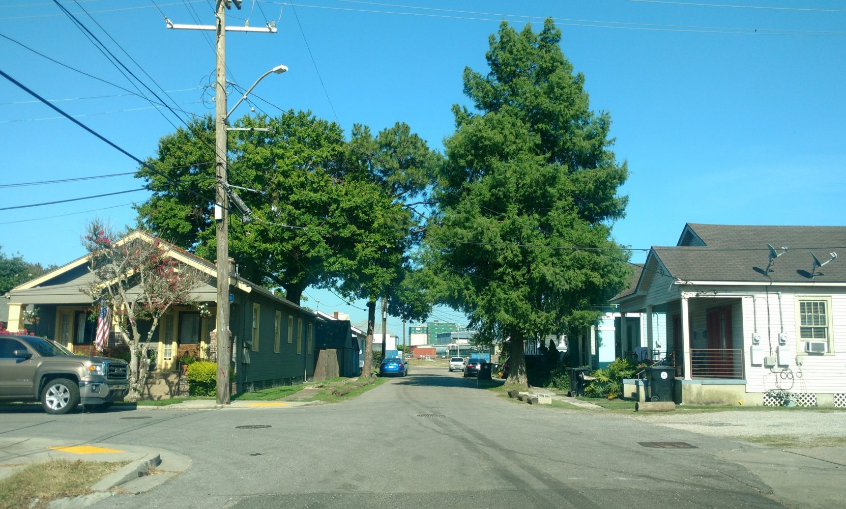
South Front Street at Eleonore Street. Photo by Richard Campanella.
Front Street in toto spanned more than 5.6 miles, slightly longer than Tchoupitoulas, making it arguably the longest street in the city. (I should note, however, that some maps of the era, officially or otherwise, also label South Front Street as “Leake Avenue” and, confusingly, as “Water Street.”
Three main factors over the course of one century, 1880s to 1980s, ended up fragmenting South Front into its current intermittent condition.
One was levees. Starting in 1879, the federal government became increasingly involved in flood control along the Mississippi River, providing funds and expertise for better levees, bank stabilization and dredging for navigation.
Levees were realigned and strengthened throughout New Orleans around the turn of the 20th century. The federal commitment expanded dramatically after the Great Flood of 1927, and following the high water of 1973, floodwalls were added within the city.
For its strategic position just within the earthen levee, segments of South Front gave way to these new flood-control devices. Certain segments of South Front became the path of the floodwall, which meant the street could no longer handle through-traffic, which made its other sections more likely to be repurposed.
Then there was port activity. In 1896, port management, once overseen by the city through an inefficient leasing system, shifted to a state agency known as the Port of New Orleans. Its board moved aggressively to modernize its facilities, including the installation of the Illinois Central Railroad’s new Stuyvesant Docks between Louisiana and Napoleon avenues. An integrated system of wharves with steel sheds and grain elevators accessed by railroad tracks, the Stuyvesant Docks subsumed additional sections of South Front Street, while the Illinois Central, together with the New Orleans Public Belt Railroad, founded in 1904, repurposed additional segments. This would continue throughout the century, culminating with the creation of the Clarence Henry Truckway, which essentially follows the former South Front corridor.
Advertisement

Back downtown, the early-1900s demise of the Sugar District on the French Quarter riverfront led to its piecemeal demolition, leaving North Front Street increasingly surrounded by empty lots.
South Front Street, meanwhile, enjoyed a resurgence that would prove to be its undoing. Long a blue-collar service road for wharf activity, South Front at the foot of Canal and Poydras became, in 1965-1968, the doorstep of the gleaming new International Trade Mart (today’s World Trade Center, now undergoing hotel conversion) and the Rivergate Exhibition Hall.
In the early 1980s, plans moved forward to hold a World’s Fair in downtown New Orleans, and planners eyed South Front from Girod to Thalia streets as being the fair’s “main street.” The 1984 Louisiana World Exposition would also feature a “Great Hall” designed as a permanent convention center, in the hope of revitalizing what promoters were calling “the Warehouse District” — that is, the former St. Mary Batture.
So quotidian a name as “South Front” would not suffice for such a grandiose boulevard, so in September 1983 the City Council ordained “that the name of the street located in the First Municipal District between Canal and Thalia now known as South Front Street is hereby changed to Convention Center Boulevard.” That name now extends up to Henderson Street.
The 1983 name change, 150 years after “Front Street” first appeared on a local map, removed the toponym from local discourse. Together with the other riverfront changes, it left the artery a study in intermittency.
Exactly where Front Street remains today depends on what one means by a “street.” City GIS specialist Christopher M. Ard, who maintains such records in the Department of Information Technology and Innovation, explained to me in an email that “the first thing (to consider is) if you’re looking for drive-able rights-of-way or are you looking for all rights-of-way.” Legally speaking, the city’s North and South Front streets right-of-way probably remains in place even for sections that have long since been removed from the public street grid.
As a maintained, drive-able street, the city’s GIS data show very specific figures. North Front Street today measures 417 feet from Bienville to Conti, while South Front Street comprises five detached fragments: 380 feet from Austerlitz to Constantinople (including five houses, a church and a shed), a mere 102 feet at the foot of Napoleon Avenue, 508 feet between Lyons and Upperline, 1,100 feet from Robert to Bellecastle, and 1,218 feet from Nashville to State.
That last segment is the only part of South Front with an appreciable number of homes and residents. It’s a quiet, pleasant three-block stretch with about a dozen modest wooden homes, plus some one-story apartments, sheds and a few enterprises.
To visitors, 5800-5900 South Front is a bit of a surprise, obscure and ensconced, part urban, part port, part small town. It’s not on the way to anywhere, so most folks never have any reason to go there. To those who live there, however, it’s home. The street also boasts fine views of the imposing cupola above the former Marine Hospital, now incorporated into Children’s Hospital.
Front Street’s total length of 0.7 miles, dispersed over six fragments, is a far cry from the 5.6 miles that once made it practically the longest street in the city.
But then again, it’s a lot longer today than it was historically, before the batture formed, when its future space fell within the slack currents of the Mississippi River.
Richard Campanella is a geographer with the Tulane School of Architecture and author of The West Bank of Greater New Orleans, Bourbon Street: A History, Bienville’s Dilemma and other books. Campanella may be reached through richcampanella.com, [email protected], or @nolacampanella on Twitter.
A gift they’ll enjoy all year long. Give a one-year PRC membership for $50 and they’ll receive Preservation in Print nine times a year.
Advertisements