


Header photo by Larry Granger
This story appeared in the June issue of PRC’s Preservation in Print magazine. Interested in getting more preservation stories like this delivered to your door nine times a year? Become a member of the PRC for a subscription!
Shuttered and fractured but still stoic, Fort Pike stands sentinel at the eastern fringe of Orleans Parish, overlooking the narrow channel of the Rigolets. The masonry fort was constructed between 1819 and 1826, making it the first in a series of Third System fortifications designed to defend the East and Gulf coasts following the War of 1812.
The fort shares a namesake with Pike’s Peak in Colorado: General Zebulon Montgomery Pike, who led two expeditions of the Louisiana Purchase for President Thomas Jefferson. Its near twin, Fort Macomb, overlooks Chef Menteur Pass; together these defenses allowed early 19th century cannons to fire on any seagoing vessels attempting to enter Lake Pontchartrain from the Gulf of Mexico. Fire, that is, by skipping cannonballs like stones across the water — a lost art of war rendered obsolete along with the forts by advances in naval artillery.
Though an invasion never came, the fort housed a garrison until 1871. A century later, it was added to the National Register of Historic Places. Many New Orleanians have childhood memories of school field trips or family outings to Fort Pike State Historic Site. Pummeled by hurricanes Katrina (2005) and Isaac (2012), it twice reopened only to be closed again in 2015 due to state budget shortfalls.
Advertisement

Paddle back in time
I set out for Fort Pike on a sunny March day with a kayak, bug spray and plenty of sunscreen, not certain what I would find, but after 10 days of social distancing in the city, willing to take my chances. Heading east along Chef Menteur Highway, I passed the overgrown parking lots of bygone businesses, middle class suburbs, then the Van Hahn Buddhist Temple and a smattering of shops with signs in both Vietnamese and English.
Already a world away from the New Orleans most tourists experience, my car glided through the towering concrete floodwalls that mark the perimeter of the Hurricane Surge Risk Reduction System. Beyond the levees, the road winds along a ridge through the green wetlands of Bayou Sauvage National Wildlife Refuge before reaching the subdivision-on-stilts of Venetian Isles. Continuing along, fishing camps line the road. Set back from the road atop piles, these sizable houses stand 20 feet or more off the ground, most with a pier and boat out back.
Fort Pike is the last turn before the highway rises to cross the Rigolets on a towering bridge completed in 2011. To my surprise, upon arrival at Fort Pike Historic Site, I found both the adjacent boat launch and the grounds of the historic site accessible. An open padlock hung neatly from the tall chain-link gate. After parking, I strolled cautiously toward the fort beneath two large live oaks, as starlings raised a cacophony in the branches above.
Starlings are birds best known for their evening murmurings, in which great flocks soar about like schools of airborne fish. One hundred European starlings were purportedly released in New York’s Central Park in 1890. The birds at Fort Pike, their distant noisy offspring, must have numbered as many.
A sign instructed visitors to pay at the small office building, but peering in the window I saw it was empty and preceded down the path. Flanked by two cannons, each stamped with the year of its manufacture, the path dipped to a wooden bridge across the fort’s shallow moat. There, a sign on the locked wooden door warned, “NO TRESPASSING.” After snapping a few photos, I obligingly turned around to resume my journey by kayak.
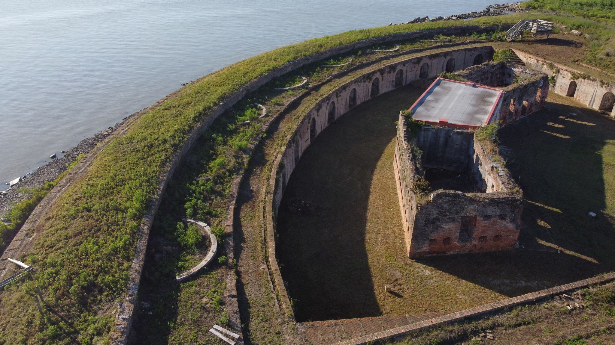
Once unloaded and in the water, Gulf Coast mud between my toes, the kayak glided swiftly through the water. Rounding a corner, Fort Pike returned to view behind a riprap breakwater that all but surrounds the structure. A small opening allows water to enter and recede, lest the stagnant moat turn fetid. The breakwater absorbs the worst of the wave action during a storm, thus slowing erosion of the fort itself and the ground beneath it.
Advertisement

This being Louisiana, natural stone must be hauled in from miles away. So, the state augmented this breakwater with the remnants of the old Rigolets bridge, erected under the administration of Gov. Huey P. Long. When it was replaced by the current span, remnants of the reinforced concrete footings were repurposed here; rebar is visible on many of the slabs, encrusted with barnacles at the water line.
First, I scouted the full seaward wall of Fort Pike, with its rhythmic openings, or casemates, from which cannons once stared across the horizon. Silver mullet leapt from the waters as I paddled by, and a great blue heron stalked the edge of a distant marsh. I scanned the scene as I bobbed on the wake of a passing recreational fishing boat.
Hoping to gain a closer view of the cracked and compromised masonry near the water line, I nosed the kayak through the narrow opening and into the moat. The water roiled with startled fish. Underwater grasses swept alongside my vessel in this shallow shelter.
Proximity afforded me a clear view of the deteriorating masonry walls. Though many wythes thick, they have begun to shed bricks where waves have eroded the mortar. In some places, there were telltale signs of inappropriate repair: a grid of hard mortar remained where bricks have crumbled like powder. A similar phenomenon of efflorescence plagues some old structures in the French Quarter, but here there is an endless supply of wind-driven salt and rising damp.
At the fort, fissures above several casemates threaten to become yawning cracks. Differential settlement damages roads and buildings in New Orleans. Here at the edge of land, the sheer weight of Fort Pike coupled with the underlying soil presents a heightened risk. At the northern corner of the fort, I noted steel beams and girders employed to shore the structure; from my limited vantage, it appeared these reinforcements have prevented cracking. Perhaps, for all its signs of wear, Fort Pike is in remarkable condition given its age and environment.
Before returning to my vehicle, I took a detour south, away from the fort and into a channel lined with moored oyster boats. To my left, a patch of roseau cane widened into a small island. I slipped into a winding inlet and was suddenly surrounded by spartina. Tufts of white clouds floated across the blue sky above green cordgrass. The twisting, narrow streams soon became too shallow even for a kayak, and I paused to marvel at the timeless quality of this ever-changing landscape.
Returning to the shore, I passed a pelican preening on water’s edge and gulls dozing on piers. It was time to load up and head back to New Orleans proper. At the moment, ours was a city under lock and key, with the businesses lining Bourbon Street boarded shut and — more troubling to most of us — neighborhood bars closed, too. It seemed the coronavirus had done what hurricanes couldn’t: put an end to the party.
Restaurants, churches, schools, museums and nightclubs suspended normal operations, and passers-by stepped sideways to keep the prescribed six feet distance from one another. The pandemic had not only dealt a blow to our economy but to our gregarious culture — the very ways of gathering that have helped us overcome crises in years past.
Special places have taken on a new salience by connecting us to people across time, putting this era of uncertainty in perspective. Like much of New Orleans, Fort Pike is closed for now. The battered bastion still standing on the edge of the Gulf Coast no longer serves as an emblem of military might, but it might do as a reminder that resilience is what defines our place and people.
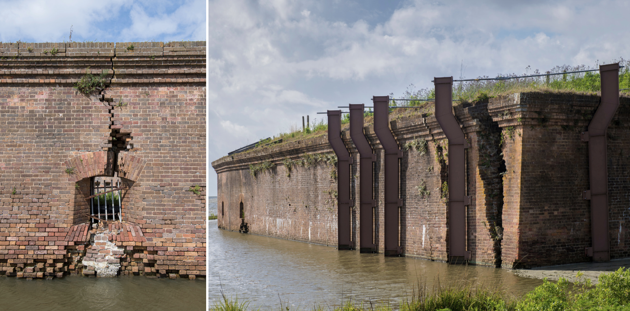
Left: Walls built to withstand cannon fire have begun to shed bricks at the waterline. They are no match for two centuries of saltwater waves. Vertical bars indicate the conversion of this casemate to a holding cell. Photo by Chris Granger. Right: Vertical steel supports and horizontal rods added to prevent further cleaving at the northernmost corner of Fort Pike are the most significant conservation intervention evident today. Photo by Chris Granger.
Lessons from the fort
If the fort is ever reopened to the public, it can teach us about more than advances in naval engineering. Following the passage of the Indian Removal Act in 1830, Fort Pike served as a way station for members of the Seminole tribe being forcefully expatriated from Florida, which the United States acquired from Spain a decade prior. They crossed paths with U.S. troops en route to wage the Second Seminole War during the presidency of Andrew Jackson. Evidence still remains of casemates converted to holding cells for the Native Americans and people of African descent living alongside them.
Later, Fort Pike was held by Confederate troops for approximately a year before being taken by the Union for the remainder of the Civil War. Federal troops used the fort to train formerly enslaved men to operate heavy artillery as part of the United States Colored Troops. These African-American soldiers would play a significant role in the 1863 Siege of Port Hudson, in which the Union finally secured control of the Mississippi River.
In addition to these historical associations, Fort Pike’s ecological setting makes it even more valuable as an educational site. Coastal land-loss and sea-level rise (each in its way accelerated by human activities) are existential threats to many places along Louisiana’s coast. But much of that coast, like the fishing camps lining Chef Menteur Highway, is private. Using our public assets to let more people experience our dynamic coast — and understand what can be done to save it — is vital to building and sustaining the political will for coastal restoration. That’s essential if we are to keep remarkable places like Fort Pike standing for future generations.
Nathan Lott is the policy research director and advocacy coordinator for the Preservation Resource Center of New Orleans.
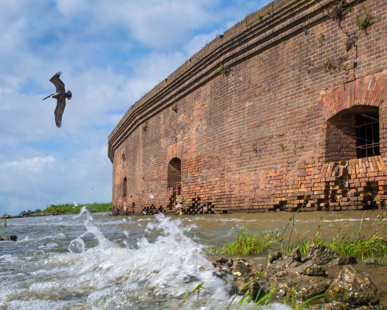
Photo by Chris Granger
Advertisements