This story appeared in the December issue of PRC’s Preservation in Print magazine. Interested in getting more preservation stories like this delivered to your door? Become a member of the PRC for a subscription!
Regular readers of “Streetscapes” are probably familiar with the Carondelet (Old Basin) Canal, that 1.6-mile channel dug from 1794 to 1796 under the oversight of Spanish Gov. Hector Carondelet. Initially designed for drainage and later for navigational access to Bayou St. John, the canal was filled in the 1920s and left derelict for nearly a century, until advocates succeeded in reactivating it as today’s Lafitte Greenway.
Though there is no longer a turning basin on Basin Street or a waterway from the rear of the French Quarter to Bayou St. John, runoff still flows along that centuries-old trajectory, via a concrete-lined drainage canal destined for Pumping Station No. 2 and ultimately Lake Pontchartrain.
All of which begs the question, how did New Orleans (that is, today’s French Quarter) discharge its runoff prior to 1794, before the Carondelet Canal was dug?
Before we delve into that, let’s first set the topographic stage.
The French Quarter sits astride the Mississippi’s natural levee, an upland produced by quasi-seasonal overtopping of sediment-laden river water. The largest quantities of the coarsest sediment particles settled immediately, shoring up the terrain, while smaller quantities of finer alluvium fell out farther back, forming the backslope of the natural levee until it petered out in the backswamp. Like most river-abutting areas in our region, the topographic profile of the French Quarter resembles a slightly inclined wedge, some 9 to 10 feet high along its Decatur/North Peters Street front and 1 to 4 feet above sea level in its North Rampart Street rear flank.
The rear of the “wedge,” however, is not evenly shaped. One corner — toward Esplanade Avenue, specifically where Gov. Nicholls Street intersects North Rampart — is 2 feet higher than the other corner, at the Canal Street end of North Rampart, which is only 1 to 2 feet above sea level. That upriver/lakeside corner is the lowest quadrant of the French Quarter, though it is nonetheless higher than the former swamplands, historically lying somewhere between today’s North Claiborne and North Broad, which with modern municipal drainage have since subsided below sea level.
The reason for this lopsided rear flank is because a secondary ridge unrelated to the river’s natural levee had the effect of “jacking up” the downriver/lakeside corner. Today we call that feature the Esplanade Ridge, but it actually underlies Bayou Road. Geologically, the Bayou Road/Esplanade Ridge most likely formed as sediment was deposited by a tributary of a former channel of the Mississippi, coursing along what is now Metairie Road, City Park Avenue and Gentilly Boulevard. As the only terrestrial pathway across this particular section of the backswamp, Bayou Road played a critical role in convincing French Gov. Bienville to select today’s French Quarter as the site for New Orleans, because the access it afforded to Bayou St. John and Lake Pontchartrain represented a valued alternative route to the sea. Seventy-six years later, Spanish Gov. Carondelet endeavored to improve that muddy city-to-bayou connection with the excavation of his eponymous drainage canal.
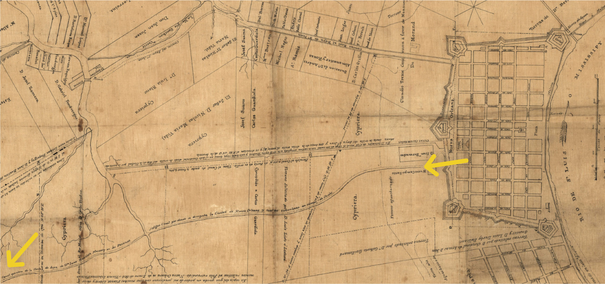
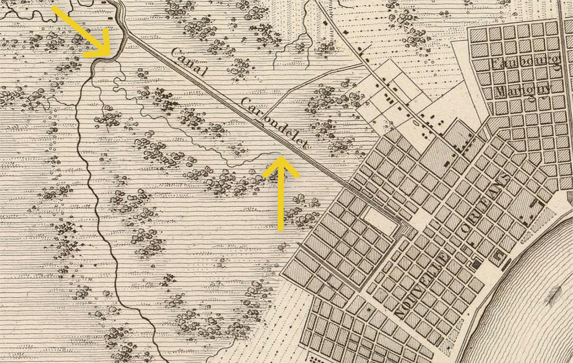
Field surveys of the city’s drainage were conducted by Vicente Sebastián Pintado and later recorded by city surveyor Carlos Laveau Trudeau. This detail image is from Pintado’s sketch made between 1795 and 1796 and set down by Trudeau in 1804.
Rendering New Orleans out of deltaic muck entailed figuring out a way to reduce runoff, be it from rainfall or river infiltration. Starting in 1722, engineers had a network of gutters excavated around each city block and the barrow mounded upon the “isle,” so that runoff drained gravitationally backwards and eventually into the moat paralleling the city’s primitive fortifications.
The moat had only so much storage capacity, so any excess runoff would have to be discharged. Most colonial maps tend to cut off their coverage at the city’s edge, and those that show areas beyond the city limits indicate outlets tended to be cursory and possibly conjectural. Cartographic depictions of the fortifications and moat are similarly erratic, perhaps with speculative or deceptive intentions, though most written accounts describe them as crudely constructed until the late Spanish colonial era.
As such, the surest “method” of discharging excess water from the moat would be to just let the overflow trickle back through dense woodlands and into the swamp. But one thing was certain: all runoff exiting the rear of the city would have naturally gravitated to that aforementioned upriver/lakeside quadrant, being the city’s lowest spot. The best way to drain colonial New Orleans, then, would be to create an outfall channel in that vicinity, with enough volume and hydraulic head to draw the runoff more efficiently out toward Bayou St. John.
Eighteenth-century maps are inconsistent as to whether such a channel had been dug here — or, alternately, whether there existed an intermittent natural tributary which workers might have connected to the city’s drainage system. Some sources show an egress of sorts here. A map from the late French colonial era, for example, shows an engineered discharge at Orleans Street at the city’s edge, though it is unclear where the water went from there. Two other maps from the early Spanish period show a footpath where Conti Street exited the rear of the city, labeled “Guardhouse of the Inhabitants.”
Greater clarity comes in the 1790s, when Gov. Carondelet took office and prioritized urban infrastructure, including rebuilding the fortifications and improving drainage and navigation. A map drafted immediately following the December 1794 fire, which destroyed 220 structures in today’s French Quarter, shows a drainage outfall at the fortification between St. Louis and Toulouse streets. Where that discharge thence flowed finally becomes apparent in field surveys conducted by Vicente Sebastián Pintado and later recorded by city surveyor Carlos Laveau Trudeau.
The Pintado map, initially surveyed during the 1795 excavation of the Carondelet Canal and revised repeatedly in upcoming decades (including by Pintado himself in Havana in 1819), is our best documentation for a bayou-like drainage outfall behind the original city. It clearly shows a narrow channel flowing from behind St. Louis Cemetery No. 1 (which the Spanish had laid out in 1789) and gently curving through today’s Fourth Ward, roughly parallel to today’s St. Louis, Iberville and Bienville streets heading toward the lake. The wending waterway crossed a natural tributary (Bayou Cannes, which once drained the Lower Garden District area) to Bayou St. John around what is now intersection of Canal Street with South Lopez Street and ended up in today’s Mid-City.
Pintado labeled the channel as Antiguo Canal por donde se desagruaba la Ciudad de Nueva Orleans y terrano suburbano en tiempo de Lluvia (“Old Canal by which the City of Orleans and suburban terrain drains in times of rain”), and in all likelihood, what made the canal “antiguo” was the brand-new Carondelet Canal, which Pintado sketched a few blocks to its right.
I know of no other map that depicts this important yet mysterious hydrological feature so extensively and descriptively. It does not appear to have been a natural tributary of Bayou St. John, because its gradual curves were not as intricate as all the other dendritic streams of that watershed. Yet curve it did, in a manner that no hydrological engineer would design intentionally, since bends increase length, weaken hydraulic head, slow water velocity, and hasten sedimentation. My best guess is that the channel formed on its own once humans concentrated city runoff and steered it to that low corner, after which workers may have helped it along by clearing and extending its channel to connect it to a true tributary of Bayou St. John to disembogue into Lake Pontchartrain.
We learn more of the mysterious waterway from the far edge of the Pintado-Trudeau map, which shows the channel continuing past its confluence with that tributary. Pintado labels that far end with the words Canal que viene de la Sierra de Agua de D[o]n Juan Bautista Macarty en los Pacanos (“Canal that comes from the water source of Mr. Jean Bautiste Macarty amongst the pecans”), which I believe refers to Bayou Metairie and the Metairie Ridge, whose forests included pecan trees, and parts of which were owned by the Macarty family. Perhaps the biggest clue that this waterway was mostly anthropogenic comes from Pintado’s gazetteer (or geographical index): he used the word “canal” twice to describe the channel, while he used “Bayu” — the phonetic Spanish spelling of the indigenous word originally pronounced Bayouk — for the natural outlet known as Bayou St. John.
By the time the ink dried on Pintado’s original sketch, the antiquo canal was just that, having been superseded by the Carondelet Canal. Yet our canal continued to serve, according to an 1801 map stored in the Spanish Archives, which shows a Canal Reciviendo las Aguas de la Ciudad (“Canal Receiving the Waters of the City”) in lieu of the moat, and perpendicular outfall canals discharging into the swamp, one of which ran from St. Louis Street past the cemetery toward the antiguo canal. An 1803 Plan of New Orleans, meanwhile, shows the portion of our canal running by St. Louis Cemetery complete with a footbridge connecting that previously mentioned footpath with the “Guardhouse of the Inhabitants.” An 1807 map also shows our canal extending from St. Louis Street, labeled Canal de ecoulement (“outflow canal”).
That 1807 map envisioned the future Canal Street, which entailed the 1810 subdivision of the blocks between the original city and its first suburb, today’s Central Business District. By that time, the old fortification had been decommissioned, while in 1810 the Faubourg Tremé had been laid out across what would become North Rampart Street. The last possible cartographical appearance of our antiguo canal, so far as I can glean, is on an 1829 inset map by Francis P. Ogden titled City of New Orleans and Its Environs, and a more detailed circa-1830 map by Guillaume Tell Poussin titled Plan du Canal de junction du Mississippi au Lac Pontchartrain, both of which show a surprisingly natural-looking (that is, squiggly) rivulet conflowing with Bayou Cannes where Bienville Street now intersects Norman C. Francis Parkway, after which the water flowed into Bayou St. John. If these two cartographic squiggles do indeed represent a transmuted version of our antiguo canal, then nature may have transformed that old colonial water-management effort into something resembling a genuine backswamp bayou.
 Detail of Guillaume Tell Poussin’s “Plan du Canal de junction du Mississippi au Lac Pontchartrain.”
Alas, nature’s victory was short-lived. Within a few decades, drainage and development would envelop the area and erase the feature from the landscape. Its contours are now so thoroughly obliterated that even modern LIDAR elevation measurements can discern nary a trace.
The only topographic trait that remains of this lost waterway is the dip in elevation of that quadrant of the French Quarter, which is still the lowest in the neighborhood — and the only part that went underwater during the deluge following Hurricane Katrina in 2005.
Richard Campanella, a geographer with the Tulane School of Architecture, is the author of The Cottage on Tchoupitoulas: A Historical Geography of Uptown New Orleans, published by the Preservation Resource Center, as well as The West Bank of Greater New Orleans — A Historical Geography (LSU Press), Bienville’s Dilemma and other books. His original study of French Quarter structures appears in his 2006 book, Geographies of New Orleans. Campanella may be reached through richcampanella.com, [email protected], or @nolacampanella on Twitter.