This story is from the archives of PRC’s Preservation in Print magazine. Interested in getting more preservation stories like this delivered to your door monthly? Become a member of the PRC for a subscription!
American dominion did not necessarily bring order to the streets of New Orleans. By some accounts they were rougher than ever, a failure that Anglo newcomers tended to blame on the Creole political establishment. One Anglo-American, pointedly signing his name AMERICANUS in an 1805 Louisiana Gazette letter to the editor, advised the mayor that “New Orleans…might be rendered as cleanly and healthy as most towns in the United States,” if only it adopted his plan to excavate brick-covered canals down streets from the river to the backswamp so that fresh water could be flushed throughout. The Anglophone newspaper that carried the letter animatedly reported another Anglo-American native of Kentucky who, “attempting to cross the street of the [Anglo-dominated] Fauxbourg St. Mary” after a heavy summer rain in 1806, “got out of his depth, and not being able to swim, was unfortunately drowned.” The editors pondered “whether…the ‘accidental death’…ought to be [held] against the corporation of the city.” One wonders whether too much liquid of a different sort may have played a role in the hapless Kaintuck’s demise.
It took another 11 years before the city finally paved its first street — Gravier, between Tchoupitoulas and Magazine, unsurprisingly in the American sector — and it took an additional five years before it launched a citywide paving campaign starting with Royal Street. That 1822 effort, however, by no means solved the problem. Residents continued to hop among puddles, trenches, mud pits and feces much like their ancestors did a century prior. Even worse were the sidewalks, which were called footpaths, foot-ways, and causeways in English, and trottoirs and banquettes in French. Old wooden sidewalks were replaced with brick ones starting in 1820, but the project proceeded only if and when funds became available. An 1827 city ordinance taxed property owners whose parcels abutted already-improved streets to pay for new sidewalks, and, in keeping with the de facto policy of prioritizing for the front-of-town at the expense of the rear of the city, specified that work begin on Royal first, then Levee, then Bourbon, Dauphine, Burgundy, and finally Rampart.
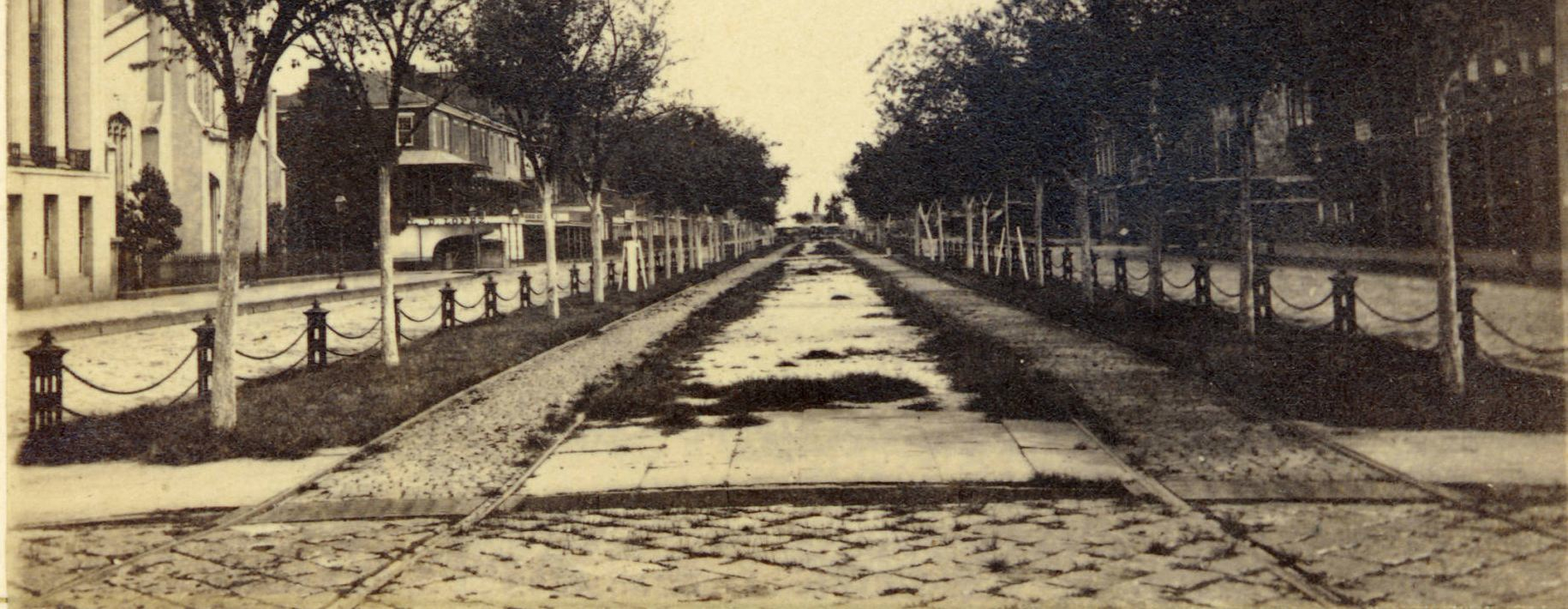
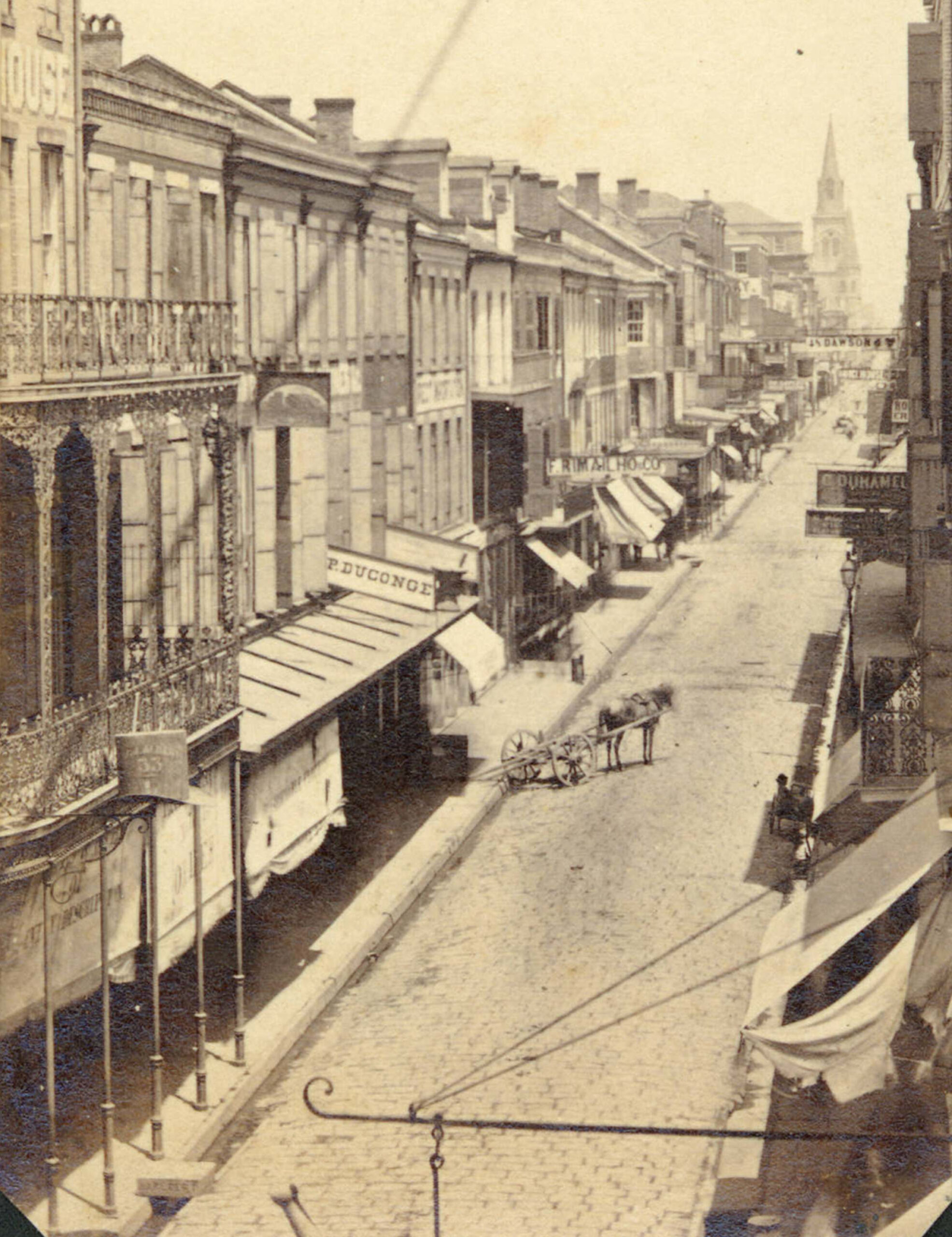
1:Paving blocks, railways, and urban forestry on Canal Street at the Rampart intersection, looking toward the river, around 1864. The Clay Statue at the Royal/Canal/St. Charles intersection is visible in the distance. Detail of photograph from Marshall Durham Collection, Louisiana State Museum, used with permission.
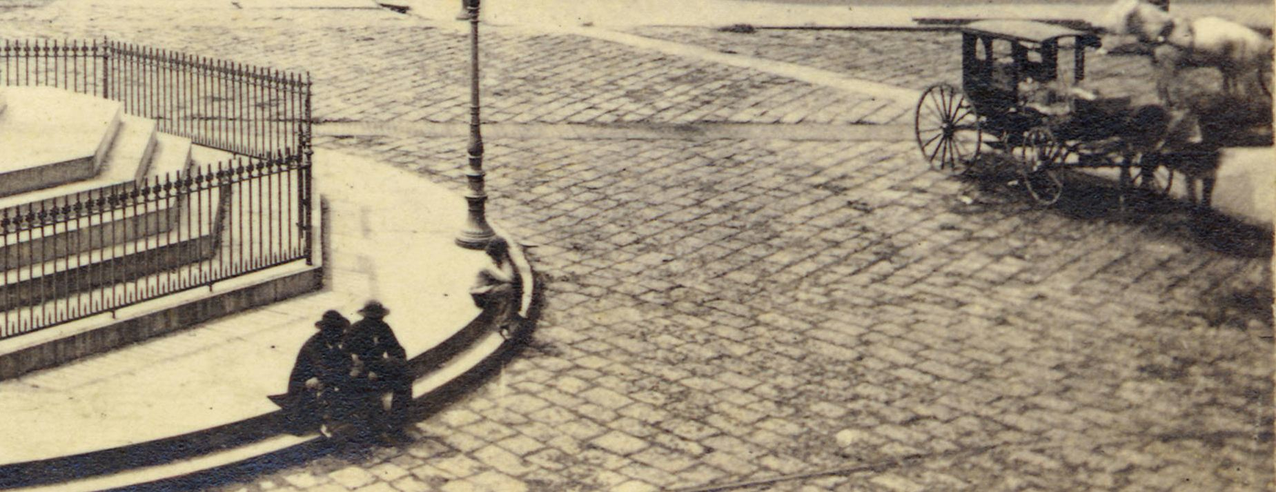
2:This detail of a circa-1864 photography shows what paving materials looked like at the busiest intersection in the absolute heart of New Orleans—where St. Charles and Royal cross Canal Street. The base of the Clay Statue, now located in Lafayette Square, appears at left. Detail of photograph from Marshall Durham Collection, Louisiana State Museum, used with permission.
Two years later, Bourbon’s trottoirs continued to generate complaints. An item in the New Orleans Argus in 1829 noted, “The sidewalks on Bourbon St. from one extremity to the other are in the most wretched state. The bricks are torn up, the gutters sunk and the edgings of the walks rotten, and in many places the walking at night is dangerous.” In the street proper, hackmen and their passengers had their teeth rattled as carriages bounced along wash-boarded surfaces. Wheels and hoof beats deepened potholes, which collected water, which in turn stagnated and produced mosquitoes, algae, slime and stench. “We were the whole of yesterday assailed by so unsavory a smell,” bemoaned one informant in the Louisiana Gazette in 1826; “the whole street from Bourbon to Royal suffered alike….[S]uch nuisances…will give us yellow fever in abundance.” Bourbon Street, despite its center-of-town position, seemed to suffer back-of-town street conditions, and became something of a rallying cry for street improvements. An ordinance in 1835 resolved to contract Mr. Claudot-Dumont “to pave, according to his method, Bourbon street from Canal to Esplanade street,” using granite curb and gutter stones (measuring 4 inches thick and at least 36 to 42 inches long) for the street edges, and “hard square paving stones” (12 inches by 8 inches by 8 inches) for the surface. Whether Claudot-Dumont did his job is unclear; what is clear is that Bourbon Street’s rough condition continued to generate a disproportionate number of citizen complaints. The city in 1838 sent around men in carts loaded with sediment to smooth over perturbations, but this too proved problematic. “Bourbon street, between Canal and St. Louis…is in filthy condition,” growled a local newspaper; “the dirt carts not having been along for several days. This is wrong, and the person to whose charge this business is entrusted, should attend to his duty.”
To equalize improvements among the competing neighborhoods of the First Municipality, the Council in the late 1830s used Bourbon Street as an experiment for a new type of paving. It involved brick and bitumen, a viscous tar-like petroleum that, when mixed with mineral aggregates, formed asphalt. “The paving of Bourbon street…from Canal to Toulouse…, so far, promises success,” reported the Picayune in 1839; “we would not be surprised to see the plan adopted throughout the city.” Paying for the improvement was borne, or at least shared, by property owners; an 1839 real estate contract declared that the new owner, cotton broker Auguste O’Duhigg, “binds himself to pay for the bitumen paving laid in font of [his] 60’ front on [present-day 626-632] Bourbon.”
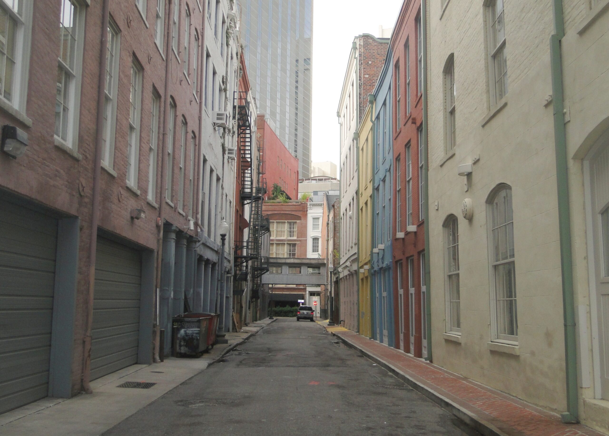
The new technique worked well at first — to the point that, according to the Picayune, “many a drayman, hackman, or cabman [goes] squares out of his way” to glide across Bourbon’s smooth surface. Problem was, the bitumen crumbled, in part because it attracted heavy traffic but mostly for reasons of application, material and subsurface. It had to be done again. “They are re-bitumenising Bourbon street,” huffed a reporter, as workers tried to fix the problem. In 1841 the municipality council abandoned the great Bourbon Street “asphaltum experiment,” resolving instead to pave it with the simpler but bumpier round stones imported as ship ballast or on flatboats from “the upcountry.” Other paving materials used on antebellum streets included cobblestones, square block and flat granite stones, rangia shells dredged from the bottom of adjacent lakes and bays, bricks, and wooden planks and gunwales stripped from flatboats. Relics of these materials may be seen today whenever a maintenance excavation or utility cut is dug in the inner city.
Paved streets meant smoother and faster flowing traffic, but also danger. Horses and mules, often driven by free people of color or hired-out slaves, pulled wagons, trucks, and drays at speeds fast enough to injure or kill unwary pedestrians. For “the Safety and Facility of traffic in the Streets,” the city in 1827 prohibited anything faster than “a stepping pace.” Speeding penalties, which were posted on walls and corners, ran five to 50 dollars for free people and 10 lashes for slaves if the master failed to pay the fine. Another ordinance banned the hitching of horses and mules to posts along the banquette, because of the damage they could inflict. Nor could one wash horses on the street. Inner city streets were generally spared the herds of cattle and hogs corralled through public arteries, but not so the suburbs: those of the upper banlieue where the flatboats docked (today’s Irish Channel) regularly suffered this stinky nuisance.
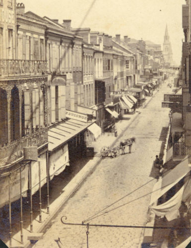
3: Upper Chartres streetscape, around 1864. Many late-nineteenth century paving stones still lay in place in the streets of the French Quarter and other historic neighborhoods, covered over by layers of concrete and asphalt. Photograph from Marshall Durham Collection, Louisiana State Museum, used with permission.
Even more critical to folks’ daily lives was domestic water. New Orleanians needed it to drink, cook, bathe and clean both inside and outside; an 1817 public-health law mandated that residents water down dusty streets and banquettes fronting their houses daily. Denizens obtained water from a variety of sources; some would purchase it from street vendors — one picayune for four buckets — or task their domestics or children to scoop it directly from the Mississippi. Others would collect rain running off their roofs or dig wells in courtyards and store the water in cisterns. For water that they would imbibe, residents would remove impurities with stone, alum or charcoal filters in earthen jars stored in courtyards or kitchens. Each method required much labor and yielded little water, creating a niche for entrepreneurs: enter the private water system. One attempt worthy of Biblical times came in 1810 on the levee at Ursulines Street. Slaves pumped river water into a raised tank, which thence flowed by gravity through hollow cypress logs to subscribers. Famed architect Benjamin H. B. Latrobe designed a better system a few years later, in which a steam engine mounted in a three-story pumphouse would draw water from the Mississippi, store it in raised cast-iron reservoirs, and distribute it to nearby basins and through a network of cypress pipes to subscribing residences or to cast-iron boxes at street corners. Latrobe’s waterworks served the city from 1823 to 1836. Subsequently, the Water Works Company assumed responsibility for water distribution, and in spring 1853, installed “large new main pipes…in place of the old small ones” from Latrobe’s system. “We have been struck,” wrote a Picayune reporter, “with the depth to which the workmen dig without reaching water.”
Garbage was collected in antebellum New Orleans six days a week by a city contractor in a horse- or mule-drawn cart, into which residents deposited “dirt, filth and kitchen offals” brought out in “tubs, hampers, [or] baskets.” Citizens had to bring their household detritus outside just as the cart approached; the contractor did not pick it up from the curb, except for dead animals and street litter. The policy kept garbage off the street but forced residences to wait endlessly listening for the cart to approach. An 1819 ordinance corrected this flaw by allowing the storage of garbage in containers “placed near the gutter of the foot way, opposite to their respective building.” Strictly forbidden by city ordinance were “dung, chips, shavings and feculent matter,” which individuals had to remove themselves. Human feces could only be moved through the streets at night and “emptied into the current of the river”—the same river that served as water source for folks downstream.
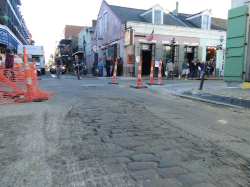
4: Recent repaving of select French Quarter streets in preparation for the 2013 Super Bowl unveiled nineteenth-century paving stones at the Toulouse Street intersection with Bourbon.
As in colonial times, illumination on Bourbon Street in the early 1800s came from oil lamps “suspended to iron chains, which are stretched from the corners of houses or high posts, diagonally across the junctions,” and tended daily by city-paid lamp-lighters who doubled as “city guards,” or policemen. Smaller, oil-fueled lamps and candles provided lighting inside New Orleans homes until, in 1834, the New Orleans Gas Light and Banking Company (later New Orleans Gas Company) commenced operating its gas plant in the rear of the American sector. Gas lines laid throughout St. Mary and the French Quarter allowed the invisible fuel to flow to paying residential, industrial and commercial subscribers, particularly theaters and exchange hotels. By the 1850s, gas also fueled city street lights, although many lanterns still used oil. The city contracted with the New Orleans Gas Company to service both gas and oil street lamps, scheduling their daily lighting and extinguishing to take full advantage of diurnal and lunar cycles and penalizing the company for malfunctioning lamps. Until electrification arrived at the end of the 19th century, the lamplighter’s task formed an integral part of the daily ritual that was life on the streets of historic New Orleans.
Richard Campanella, a geographer with the Tulane School of Architecture, is the author of Bienville’s Dilemma, Geographies of New Orleans, Lincoln in New Orleans, and other books. This is an excerpt from an upcoming book by Campanella. Footnotes and sources will appear in the final version. Campanella may be reached through richcampanella.com or [email protected]. Follow him on Twitter @nolacampanella.