


Cities, like our personal lives, often end up a patchwork of plans woven together amid the vicissitudes of history, sometimes ending up looking like crazy quilts.
Older American cities—Boston and Manhattan, for example—typically exhibit chaotic cores surrounded by more regularized peripheries. Younger cities like Phoenix and Las Vegas, planned since their inception, largely comprise rectangular grids oriented to the cardinal directions. Salt Lake City’s “Plat of Zion” exudes Euclidean geometry, complete with a XY-coordinate addressing system.
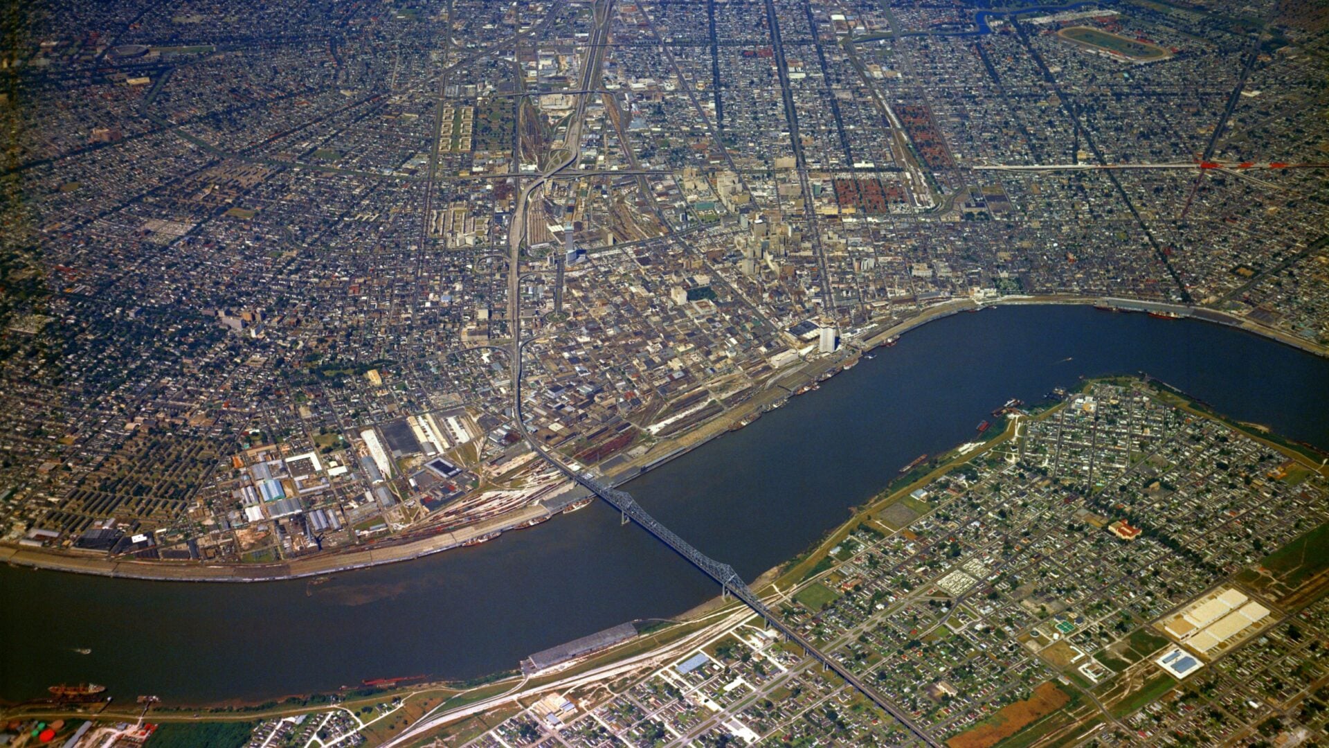
New Orleans presents an interesting case study in which spatial order (that is, professional planning) grappled with deltaic dynamism and market forces—before, during, and after the age of modern engineering. What resulted is a metropolis replete with attempts at rationality and innovation, but subjected to pragmatism and replication, and sprinkled with occasional bedlam.
Unlike Boston and New York, which grew spontaneously for well over a century before professional planners intervened, New Orleans endured only four years unplanned development. It commenced with the founding of the city in the spring of 1718 and ended when a September 1722 hurricane wiped away the desultory settlement, allowing assistant engineer Adrien de Pauger to lay out the orderly plan he first sketched a year and a half earlier.
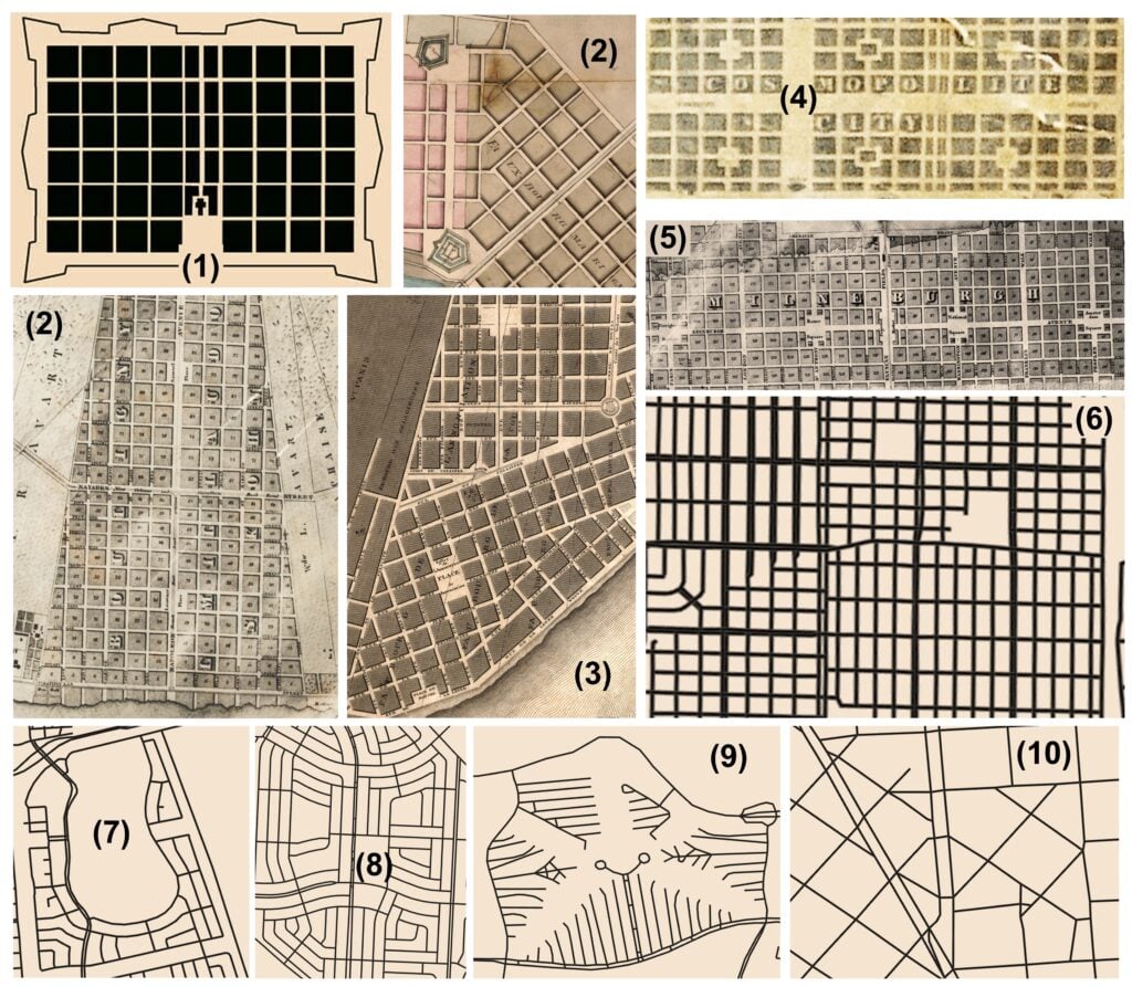
Pauger’s plan (1 on accompanying graphic) was a masterful execution of the orthogonal grid, an urban design that had originated in ancient Greece and spread worldwide via European colonialization. Surveyed in late 1722, Pauger’s plan comprised a six-by-eleven-square grid with institutions of church and state fronting an ornamental plaza. He positioned the envisioned city upon the crest and backslope of the natural levee, angled it so as to confront enemy ships with corner bastions, and surrounded it with defensive ramparts.
As rigid as the delta is fluid, New Orleans’ first urban plan reflected design principles articulated by Vitruvius in 20 B.C., among them ordinatio (measured regularity), symmetria (proportionality) and eurythmia (natural adaptivity). “All the streets are laid out both in length and breadth [to] cross each other at right angles,” wrote Le Page du Pratz of New Orleans in the 1730s. “The streets divide the town into fifty-five isles,” each of which “is fifty square toises, and each again divided into twelve emplacements…for lodging as many families.”
Pauger’s design, today’s French Quarter, spanned less than a mile in frontage, not quite enough for the meandering river to impose a bend upon the urban rectitude. That changed in 1788, when New Orleans first expanded—into the adjacent plantation of the Gravier family, becoming the Faubourg Ste. Marie, today’s Central Business District. The city expanded in 1805, this time in a downriver direction, with the surveying of the Faubourg Marigny.
Urban expansion continued nonstop into the 1850s, by which time nearly twelve miles of natural levee had been laid out with street networks, from Carrollton down to today’s Lower Ninth Ward, plus ridges extending back to Bayou St. John and along parts of the Metairie and Gentilly roads. Few of these new urban subdivisions bore the ordinatio and symmetria of Pauger’s original plan. Two reasons explain why.
Firstly, the morphology of the terrain on which they were built curved unhelpfully, being within the broad crescent of the Mississippi or along wending ridges. Secondly, the French long-lot cadastral system, in which holdings had been surveyed to front the river and slice across the natural levee, produced parcels that were always elongated and rarely rectangular. Rather, they converged on the concave side of a meander (today’s Uptown) and diverged on the convex side (today’s West Bank).
What resulted was a serpentine sequence of isosceles triangles or trapezoids of various proportions. Because these plantations underwent urbanization in a bottom-up manner (whenever the planter family decided to sell and subdivide), courtesy of various surveyors (whomever the family happened to hire), the streets and blocks of the new subdivisions ended up getting squeezed into off-plumb parcels. What resulted were arrays of what I would call “attenuated grids” (marked 2 on graphic), each with the same symmetrical intent of Pauger’s plan, but tweaked, tapered, or twisted to fit parcel idiosyncrasies.
Look just about anywhere in the historic district outside the French Quarter, and you’ll see these attenuations. Most work reasonably well, though rarely perfectly, being interspersed with slender slivers, misaligned intersections, and inconsistent street widths and lengths. Think of all those times you’ve had to pull over for an oncoming car on Perrier, or Coliseum, or Chestnut streets. Or when you’ve had to maneuver around odd street jogs at Franklin Avenue, Felicity, Joseph or Lowerline streets (all former long-lot plantation boundaries). Think also how it takes four times longer to drive from Louisiana to Napoleon along Tchoupitoulas than along South Broad. Through the attenuation of standard grids to fit tapered long-lots, various plans devised over decades merged together to form a patchwork city.
There is one glorious exception. In 1806, the French-born ingénieur géographe Barthélemy Lafon brought his Classical training to the rare opportunity of conflating four adjacent long-lot plantations—those of the Delord-Sarpy (Duplantier), Saulet (Solet), Robin, and Livaudais families—enabling him to erase the boundaries therein and make space for a grandiose vision. What Lafon produced is a type of Grand Manner or Baroque plan (3 on graphic), featuring radial streets; plazas including a rotary (now Harmony Circle); civic spaces for gatherings; markets, a church, a school, and an elaborate stormwater management system, all adorned with imaginative Greek toponyms. Completed in 1810 and known today as the Lower Garden District, Lafon’s legacy in New Orleans brings to mind the work of two French contemporaries: Pierre-Charles L’Enfant, who in 1791 laid out Washington, D.C. with a full articulation of the Grand Manner Plan, and Arsène Lacarrière Latour, who in 1805 created a more modest interpretation for downtown Baton Rouge.
The 1830s marked an apex in creative urban designing in New Orleans, though the visions rarely made the leap from paper to land. Inspiration came from across the nation. One involved the New England tradition of town plans, in which an axial green fronts a public meeting house to herald the ideals of a secular democracy beholden to the people. Another came from the city plan of Savannah, Georgia, in which broad boulevards are interspersed by cellular wards, each positioned around parks nested within major street intersections. Designed by James Edward Oglethorpe, the Savannah or Oglethorpe Plan reflects Enlightenment-era ideals of social equality in the distribution of urban amenities.
Both concepts apparently impressed Nicholas Noël Destréhan, a grand esprit of the West Bank who, like so many other planters, sought to urbanize his riverfront parcels. In 1836 he hired surveyor Pierre Benjamin Buisson, who had previously surveyed a number of those attenuated grids on the East Bank, to sketch a plan for Mechanickham, a name Destréhan hoped would appeal to the families of German tradesmen (mechanics) settling in New Orleans proper.
Buisson devised a rarity for Louisiana—a village-like commons fronting a courthouse or city hall (as opposed to a church), paralleled by twin boulevards extending to the riverfront. In time, Mechanickham would become Gretna; the twin boulevards would be named Huey P. Long Avenue; and the Buisson/Destréhan plan would rank as one of Louisiana’s few examples of a New England-style town. (There is another one in, of all places, the Village of St. Joseph in Tensas Parish, population 800.)
Just upriver from his Mechanickham project, Destréhan envisaged another subdivision he named Cosmopolite City (5 on graphic), for which he sketched an impressive rendition of Oglethorpe’s plan for Savannah. Lofty aspirations led Destréhan to coin worldly street names for Cosmopolite City, including Persian, Turk, English, Italian, Spanish, and Russian, all around a main avenue called Paradise.
It is unclear if Destréhan got the Oglethorpe Plan idea directly from Savannah, or from just across the river. A couple of years earlier, when the Pontchartrain Railroad opened on Elysian Fields Avenue to access Lake Pontchartrain, Scottish proprietor Alexander Milne had a subdivision designed for his lakefront land. Named Milneburgh (or Milneburg, 6 on graphic), the layout appears on the 1834 Charles Zimpel Map as having some of the same worldliness of Cosmopolite City (avenue names like Paris, London, and Edinburgh), a grand boulevard leading to waterfront wharfs (as in Gretna), and four Savannah-style corner parks straddling major intersections, named Foreign, Rome, National, and Amsterdam Square.
Appearing only on the Springbett and Pilié Map of 1839, Cosmopolite City never came to fruition; the Panic of 1837 had delayed the project, and the Oglethorpe Plan fell by the wayside. Years later, surveyors laid out a standard attenuated grid to create the modern community of Harvey, named after Destréhan’s son-in-law.
Milneburg, on the other hand, rolled forward, and despite persistent lake flooding, endured into modern times to become part of today’s Gentilly neighborhood, with some elements traceable to the 1830s. If you look closely at where Allen Toussaint Boulevard intersects St. Roch Avenue, you’ll see four city-owned corner parks known as Rome and National Square. Imagine those four spaces unified as one green square nestled within Toussaint Boulevard, and that’s about as close as New Orleans has to an Oglethorpe Plan.
Speaking of the lakefront, its urbanization in the early 1900s opened up unfettered space for urbanization at the dawn of the automobile age. Real estate developers responded by planning subdivisions which would have been unthinkable in the cramped historical section of the city. Most of the new neighborhoods were rectilinear grids, such as in Lakeview and Gentilly (6 on graphic), only now the blocks were larger and more oblong. Other subdivisions embodied bending streets, particularly in East Jefferson Parish, while other systems were wholly curvilinear—to calm traffic and abate monotony, as per recommendations made by the Federal Housing Authority. Of these new curvaceous plans, some were built around golf courses, such as Pontchartrain Park (7 on graphic), Eastlake, Timberlane, and English Turn, and others around ornamental lagoons (as throughout New Orleans East) or shopping centers (such as in Terrytown, 8).
Perhaps New Orleans’ most interesting modern design is in Lake Vista (9). Sketched in 1936 and developed mostly after World War II, this lakefront neighborhood embodies the Garden City Plan, proposed in 1898 by Ebenezer Howard as a way to reconcile the appeal of country living with the opportunities of city life. His solution was to create neighborhoods in a hub-and-spoke design such that residents could walk along leafy pedestrian corridors to access services in the hub (shops, school, church), while cul-de-sacs would enable vehicular access from the perimeter. Howard’s plan minimized street intersections and maximized greenery while still accessing urban jobs and assets. In Lake Vista today, residents open their front doors to oak trees and stroll beneath their green canopies for up to two thousand feet, crossing only one street to reach the Bird’s Nest Café (avian toponyms pervade Lake Vista). Now that’s good planning.
And then there is occasional bedlam—where agents acting at separate times with different motivations, amid economic uncertainties and legal ambiguities, end up producing, in one magnificent case, a crazy quilt of road fragments, ad-hoc street names, and a nearly eight-point intersection. I refer to that Seventh Ward interstice (10) bounded on the outside by St. Bernard Avenue, North Galvez, Allen and North Roman.
As to what happened on the inside, we’ll save that for another Streetscapes.
STREETSCAPES is written by Richard Campanella, a geographer with the Tulane School of Architecture and author of Draining New Orleans, The West Bank of Greater New Orleans, Bienville’s Dilemma, and other books.
Campanella may be reached through richcampanella.com, [email protected], or @nolacampanella on X. For more on that crazy-quilt section of the Seventh Ward, click here.